
(mirror) Spratly Islands beyond Chinese borders since ancient times
The Spratly Islands have been beyond the Chinese borders since ancient times------South and East China Sea: It is time to set aside the false history.
Independent Opinion@CommonWealth Magazine, 27/06/2016
See also: https://www.academia.edu/26907258/
Original Chinese: http://opinion.cw.com.tw/blog/profile/52/article/4458
Japanese version: http://senkaku.blog.jp/2016070362768480.html
Annotation: English transliterations of proper names are shown by Japanese pronunciations, followed by Mandarin (Mdr.) pronunciations, with occasional use of common English names such as Amoy, Jao Tsung-I, etc.
by Nozomu Ishiwi
(Associate Professor, Nagasaki Junshin Catholic University, and Investigation Committee Member, Center for Island Studies, Sasakawa Peace Foundation)
Today, June 6, 2016, upon New Power Party Legislator Freddy Lim’s questioning on the sovereignty of Taihei-tou (Mdr. Taiping Dao, or Itu Aba Island), Deputy Foreign Affairs Minister Leo Chen-jan Lee responded that it is mainly based on international law, and did not fully refute the historical basis. Legislator Lim further stated that the Shin Empire (Mdr. Qing Empire) gravestone, travel notes, etc are all illusions, and the new regime should not deviate from history to claim sovereignty to become the laughingstock of the world. The Deputy Minister agreed.
https://www.youtube.com/watch?v=mwf4Z60RhTI
This should have been a major news story. However, it was only reported by a Liberty Times journalist Tseng Weichen (http://news.ltn.com.tw/news/focus/paper/997841), and likely went unnoticed by the Japanese and Americans. The Deputy Minister’s words can be interpreted as a call to stop flashing false history. This will be an important policy of Tsai Ing-wen’s new government with significant impact. On the same issue of the sovereignty of Taihei-tou, whether to play with false history or follow true history are as far apart as heaven and earth.
Legislator Lim’s use of the word “illusions” is a mere generalization, and we should view the matter from two perspectives. The first is based on records of civilian activities abroad. Legally, this is insufficient as basis of sovereignty. It is difficult to conclude if the inscription “Shin Empire Kaku family”(Mdr. Qing Empire Guo family) on the old gravestone on Taihei-tou is genuine or fake. If this is really the remains of the Shin Empire, it may have been left by the people of the Kainan (Mdr. Hainan) Island. During the 19th century, fishing activities in the South Sea were mainly performed by Kainan Islanders. If this is used as the basis of sovereignty, then Taihei-tou should belong to Kainan Island. Even if the People's Liberation Army is to occupy Taiwan, the administrative rights of Taihei-tou should still belong to Kainan Island, and Taiwan will have no part in this. Taihei-tou only became a part of Taiwan after Taiwan was occupied by Japan.
The second perspective is guilty of quoting out of context and distorting words to fabricate history, which borders fraud. Regardless of Taihei-tou’s sovereignty, fabricating false history is the greatest crime of all and despised by all. For example, the foreign affairs ministries of both the Nationalist and Communist parties both claimed that the earliest record of Spratly appeared in “Ibutsu-Shi (Mdr. Yiwu-zhi)” by Youfus (Mdr. Yangfu) of Empire Kan (Mdr. Han). The four words Cho-kai Ki-tou (Mdr. Zhang-hai Qi-tou) appeared in this book and Chokai was taken to mean the South Sea while Kitou was interpreted as a reef. From this, it was believed that the Kan people discovered the Spratly Islands. In actuality, this is from Nanshu-ibutsu-shi (Mdr. Nanzhou-Yiwu-Zhi), written during the Three Kingdoms Period by Banshin (Mdr. Wanzhen) of Son-Go (Mdr. Sun Wu). Above this excerpt are the words “Gaikyo Taihaku” (Mdr. Waijiao Dabo, foreign vessels) and "Tetsu-you Ko-shi" (Mdr. Tie-ye Go-zhi, be ironclad). This was already mentioned in an essay by Jao Tsung-I, the grandmaster of history, in 1970.
(http://public.dha.ac.cn/Content.aspx?id=983907320776&Page=5)
Gaikyo (Mdr. Waijiao) refers to foreign, and indicates that this was a record of the discovery of the Spratly Islands by foreigners, and contradicts the claims by the foreign affairs ministries of both parties.
Go Shizon (Mdr. Wu Shicun), President of the National Institute for South China Sea Studies of the People’s Republic of China, published a book entitled "The Origin and Development of Nansha Disputes" (Chinese Economic Publishing House, 2010), and rightly cited the words “Chokai Kitou". The book was also published in English where Gaikyou Taihaku (Mdr. Waijiao Dabo) was translated as “boats used by foreigners” [1]. This represents only the most general translation by an unknown translator. However, if President Go Shizon translated this himself, he could have only used the word “foreigner”. It is inconceivable that he did not know the meaning of Gaikyou. It must be considered fraud for an expert to knowingly make a mistake. Members of the think tank of former President Ma Ying-jeu must also have understood this simple fact. However, they recklessly believed that deception of the moment was sufficient and that the Americans would not uncover the details.
[1] (see Wu Shicun, “Solving Disputes for Regional Cooperation and Development in the South China Sea: a Chinese Perspective”, page 18, Chandos Publishing, 2013.)
The southern border of the Min & Shin (Mdr. Ming & Qing) Empires was the Kainan (Mdr. Hainan) Island, and what lied beyond this border was considered foreign. Official Gazetteers attest this fact, and the Spratly Islands were never incorporated as territory. In addition to official records, unofficial geological works have similar descriptions of the border. During the middle to late Shin Empire, Gan Shisou (Mdr. Yan Sizong) recorded Banri Sekitou (Mdr. Wanli Shitang, ie long stone dyke extend for 10,000 Ri, ie 5,000 km, 3,100 miles) in his "Nanyo-Reisoku" (Mdr. Nanyang Lice, ie south sea inference), stating that “this dyke marks the Chugai border”. The Chugai (Mdr. Zhongwai) refers to inside-outside. Nine-dotted line experts all believe that he was referring to the Spratly Islands. However, a closer reading of the upper and lower portions of the original text reveals that east of the Sekitou were the oceans of Fukken (Mdr. Fujian) and the west of the Sekitou was Singapore. The deviation in the north-south border is too large. This is in fact one type of “illusions” that Legislator Lim expressed; it is completely illegitimate according to international law standards, but worthy of pondering according to historical standards.

Nanyo-Reisoku (Mdr. Nanyang Lice) excerpted from Kaikoku Zushi (Mdr. Haiguo Tuzhi), the revised edition of the first year of Kousho (Mdr. Guangxu) Rule, owned by Peking University, now from archive.org.
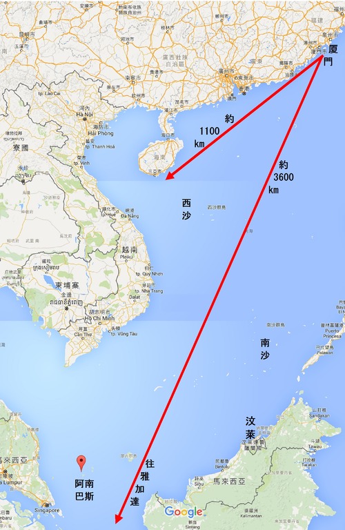
For now, we may consider this Sekitou as a north-south undersea range. The range surfaces at the north as the Paracel Islands, and at the south as the Anambas Islands on the east of Singapore. No record of the Spratly Islands was recorded in between. The Chugai border was noted in the earlier part of the original text, near the section discussing the Fukken oceans, and thus should refer to the Paracel Islands. This location is close to the Kainan border described in the official gazettes. Nine-dotted line experts deemed this as the Spratly Islands without further textual investigation. This is far-fetched and a deviation from the original text.
Tracing back to early records of the “Sekitou”, Ou Dai-en (Mdr. Wang Dayuan) of Empire Gen (Mdr. Yuan) described in his “Tou-i-Shiryaku” (Mdr. “Daoyi-Zhilue”) that the 10,000 Ri (Mdr. Li) long “Sekitou” is an undersea ley line that begins at Choshu (Mdr. Chaozhou) and splits into three separate ranges going south. The first extends east to Brunei and the Timor Island, the second extends west to western sea, and the central range threads to Java. The “Sekitou” defined by Gan Shisou (Mdr. Yan Sizong) in “Nanyo-Reisoku” (Mdr. Nanyang Lice) was likely derived from the ranges described by Ou Dai-en, and referred to either the west range or the central range, but could not have been the east range. In short, the ley line is the best explanation of the vastness of the north-south deviation.
Figure: Anambas Islands (downward leftside)

“Nanyo-Reisoku” also states, immediately following the “Sino-barbarian inside-outside border”:
“The Chinese boats were frail and the sailors were unfamiliar with meteorology…… thus, could not take to the open oceans. North of the Sekitou is the Shichi-Shu-yo (Mdr. Qi-Zhou-Yang).”
This description regarding the frailness of the Chinese boats and sailors’ lack of meteorological knowledge reflected in contrast the strength of foreign ships and foreign sailors’ familiarity with meteorology. These were determining factors in the ability to sail the vast outer seas. These outer seas likely referred to the open waters south of the Paracel, and not the archipelago water area to the east of Singapore, near Borneo. If this is the case, then “Sekitou” here should refer to the Paracel Islands north of the outer seas and the “Shichi-Shu-Yo” should be the waters adjacent to Kainan (Mdr. Hainan) Island further north. The current “Shichi-Shu-Yo” is located to the northeast of Kainan Island, in agreement with this description. As to the Spratly Islands, they are located far outside of the open oceans and did not belong to the Shin (Mdr. Qing) Empire.
There are also records of the “Chugai (inside-outside) border” in civilian travel notes. During the Kenryu (Mdr. Qianlong) rule, Chin Kosho (Mdr. Chen Hongzhao) recorded in “Hayu Kiryaku” (Mdr. Bayou Jilue) that:
“The sea lane connecting Amoy and Kalapa is 240 Kou (Mdr. Geng). On initial sailing, the boat headed southwest for 36 Kou, to the Shichi-Shu-yo. There are no islands and this is the lane that must be sailed to reach western sea……The Chugai border divides here.”
“Sho Ryukyu Manshi” (Mdr. Xiaoliuqiu Manzhi) Volume 6 quotes Hayu kiryaku (Mdr. Bayou Jilue), edition of the 31st year of Kenryu rule, from National Diet Library collection.

In this essay, where is “Shichi-Shu-Yo” located? Kalapa is a port in Jakarta. “Kou” (Mdr. Geng) is a unit of measurement in maritime navigation and is equal to approximately 60 Ri (Mdr. Li, 30 km or 19 miles). Sea lanes along the shores from Amoy to Hainan Island were mostly straight while lanes from Hainan Island to Jakarta were mostly sinuous. If the 240 Kou of the sinuous lanes is halved and calculated as 120 Kou, then 36 Kou would be equal to three-tenths of the distance. This is in agreement with ratios of straight line distances between Amoy, Hainan Island and Jakarta in modern maps. It is thus known that “Shichi-Shu-Yo” in “Hayu kiryaku” is approximately located near the Hainan Island.
In Kanbun (Kanji writing style, similar to Latin of Italy), “Chugai” refers merely to the interior and exterior, and not specifically to the Shin Empire and foreign countries. Chin Kosho only spoke of “inside-outside” and not “Sino-barbarian”. However, its location is consistent with the country border at Kainan Island. It can thus be concluded that the Chin Kosho’s “Chugai border” refers to the interior and exterior of the country border. This can be used to support the location of the Chugai (inside-outside) border as described in “Nanyo-Reisoku”. It is worth mentioning that there also exists an Chugai border to the east of the Senkakus in the East China Sea that marks the inside and outside of Ryukyu (Mdr. Liuqiu) kingdom, but the Ryukyu castle is inside, China is outside. This contradicts “Hayu Kiryaku”, as I have already reviewed and verified.
The original of Chin Kosho’s “Hayu Kiryaku” is long lost, and the above excerpt is found in “Sho Ryukyu Manshi” by Shu Shikai (Mdr. Zhu Shijie). “Sho Ryukyu Manshi” was collected in “Taiwan Bunken Soukan” (Mdr. Taiwan Wenxian Congkan, or Taiwan old documents series) of 1957, which has been widely circulated the past 50 years. Nine-dash line experts avoid discussing the Chugai border described in “Hayu Kiryaku” and only use “Nanyo-Reisoku”, with vast north-south deviation, to forcefully move the inside-outside border to the Spratly Islands and misleading the public.
“Hayu Kiryaku” is a travel note to Jakarta, and according to Legislator Freddy Lim, it should be categorized as a type of illusion. Strictly according to international laws, most historical materials prior to the 19th century are illusions. If the standard is relaxed, then there are some that are real and some that are not. They cannot be generalized. The Chugai border in “Hayu Kiryaku” matches the Kainan Island border recorded in past local chronicles, and should be taken as real.
The above is only a single example but it can already be known that the nine-dash line can be easily refuted through a discussion of history. While we cannot apply these historical materials to modern international affairs, if we avoid discussing history, we may not expose the historical fraud of the nine-dash line. The result will give the world a notion that “although the nine-dash line is against international laws, it must be respected because it is a part of history”. This is detrimental and is exactly the goal of the Peoples Republic of China.
.
Spratly Islands have been beyond Chinese borders since ancient times
The Spratly Islands have been beyond the Chinese borders since ancient times------South and East China Sea: It is time to set aside the false history.
Independent Opinion@CommonWealth Magazine, 27/06/2016
See also: https://www.academia.edu/26907258/
Original Chinese: http://opinion.cw.com.tw/blog/profile/52/article/4458
Japanese version: http://senkaku.blog.jp/2016070362768480.html
Annotation: English transliterations of proper names are shown by Japanese pronunciations, followed by Mandarin (Mdr.) pronunciations, with occasional use of common English names such as Amoy, Jao Tsung-I, etc.
by Nozomu Ishiwi
(Associate Professor, Nagasaki Junshin Catholic University, and Investigation Committee Member, Center for Island Studies, Sasakawa Peace Foundation)
Today, June 6, 2016, upon New Power Party Legislator Freddy Lim’s questioning on the sovereignty of Taihei-tou (Mdr. Taiping Dao, or Itu Aba Island), Deputy Foreign Affairs Minister Leo Chen-jan Lee responded that it is mainly based on international law, and did not fully refute the historical basis. Legislator Lim further stated that the Shin Empire (Mdr. Qing Empire) gravestone, travel notes, etc are all illusions, and the new regime should not deviate from history to claim sovereignty to become the laughingstock of the world. The Deputy Minister agreed.
https://www.youtube.com/watch?v=mwf4Z60RhTI
This should have been a major news story. However, it was only reported by a Liberty Times journalist Tseng Weichen (http://news.ltn.com.tw/news/focus/paper/997841), and likely went unnoticed by the Japanese and Americans. The Deputy Minister’s words can be interpreted as a call to stop flashing false history. This will be an important policy of Tsai Ing-wen’s new government with significant impact. On the same issue of the sovereignty of Taihei-tou, whether to play with false history or follow true history are as far apart as heaven and earth.
Legislator Lim’s use of the word “illusions” is a mere generalization, and we should view the matter from two perspectives. The first is based on records of civilian activities abroad. Legally, this is insufficient as basis of sovereignty. It is difficult to conclude if the inscription “Shin Empire Kaku family”(Mdr. Qing Empire Guo family) on the old gravestone on Taihei-tou is genuine or fake. If this is really the remains of the Shin Empire, it may have been left by the people of the Kainan (Mdr. Hainan) Island. During the 19th century, fishing activities in the South Sea were mainly performed by Kainan Islanders. If this is used as the basis of sovereignty, then Taihei-tou should belong to Kainan Island. Even if the People's Liberation Army is to occupy Taiwan, the administrative rights of Taihei-tou should still belong to Kainan Island, and Taiwan will have no part in this. Taihei-tou only became a part of Taiwan after Taiwan was occupied by Japan.
The second perspective is guilty of quoting out of context and distorting words to fabricate history, which borders fraud. Regardless of Taihei-tou’s sovereignty, fabricating false history is the greatest crime of all and despised by all. For example, the foreign affairs ministries of both the Nationalist and Communist parties both claimed that the earliest record of Spratly appeared in “Ibutsu-Shi (Mdr. Yiwu-zhi)” by Youfus (Mdr. Yangfu) of Empire Kan (Mdr. Han). The four words Cho-kai Ki-tou (Mdr. Zhang-hai Qi-tou) appeared in this book and Chokai was taken to mean the South Sea while Kitou was interpreted as a reef. From this, it was believed that the Kan people discovered the Spratly Islands. In actuality, this is from Nanshu-ibutsu-shi (Mdr. Nanzhou-Yiwu-Zhi), written during the Three Kingdoms Period by Banshin (Mdr. Wanzhen) of Son-Go (Mdr. Sun Wu). Above this excerpt are the words “Gaikyo Taihaku” (Mdr. Waijiao Dabo, foreign vessels) and "Tetsu-you Ko-shi" (Mdr. Tie-ye Go-zhi, be ironclad). This was already mentioned in an essay by Jao Tsung-I, the grandmaster of history, in 1970.
(http://public.dha.ac.cn/Content.aspx?id=983907320776&Page=5)
Gaikyo (Mdr. Waijiao) refers to foreign, and indicates that this was a record of the discovery of the Spratly Islands by foreigners, and contradicts the claims by the foreign affairs ministries of both parties.
Go Shizon (Mdr. Wu Shicun), President of the National Institute for South China Sea Studies of the People’s Republic of China, published a book entitled "The Origin and Development of Nansha Disputes" (Chinese Economic Publishing House, 2010), and rightly cited the words “Chokai Kitou". The book was also published in English where Gaikyou Taihaku (Mdr. Waijiao Dabo) was translated as “boats used by foreigners” [1]. This represents only the most general translation by an unknown translator. However, if President Go Shizon translated this himself, he could have only used the word “foreigner”. It is inconceivable that he did not know the meaning of Gaikyou. It must be considered fraud for an expert to knowingly make a mistake. Members of the think tank of former President Ma Ying-jeu must also have understood this simple fact. However, they recklessly believed that deception of the moment was sufficient and that the Americans would not uncover the details.
The southern border of the Min & Shin (Mdr. Ming & Qing) Empires was the Kainan (Mdr. Hainan) Island, and what lied beyond this border was considered foreign. Official Gazetteers attest this fact, and the Spratly Islands were never incorporated as territory. In addition to official records, unofficial geological works have similar descriptions of the border. During the middle to late Shin Empire, Gan Shisou (Mdr. Yan Sizong) recorded Banri Sekitou (Mdr. Wanli Shitang, ie long stone dyke extend for 10,000 Ri, ie 5,000 km, 3,100 miles) in his "Nanyo-Reisoku" (Mdr. Nanyang Lice, ie south sea inference), stating that “this dyke marks the Chugai border”. The Chugai (Mdr. Zhongwai) refers to inside-outside. Nine-dotted line experts all believe that he was referring to the Spratly Islands. However, a closer reading of the upper and lower portions of the original text reveals that east of the Sekitou were the oceans of Fukken (Mdr. Fujian) and the west of the Sekitou was Singapore. The deviation in the north-south border is too large. This is in fact one type of “illusions” that Legislator Lim expressed; it is completely illegitimate according to international law standards, but worthy of pondering according to historical standards.

Nanyo-Reisoku (Mdr. Nanyang Lice) excerpted from Kaikoku Zushi (Mdr. Haiguo Tuzhi), the revised edition of the first year of Kousho (Mdr. Guangxu) Rule, owned by Peking University, now from archive.org.
For now, we may consider this Sekitou as a north-south undersea range. The range surfaces at the north as the Paracel Islands, and at the south as the Anambas Islands on the east of Singapore. No record of the Spratly Islands was recorded in between. The Chugai border was noted in the earlier part of the original text, near the section discussing the Fukken oceans, and thus should refer to the Paracel Islands. This location is close to the Kainan border described in the official gazettes. Nine-dotted line experts deemed this as the Spratly Islands without further textual investigation. This is far-fetched and a deviation from the original text.
Tracing back to early records of the “Sekitou”, Ou Dai-en (Mdr. Wang Dayuan) of Empire Gen (Mdr. Yuan) described in his “Tou-i-Shiryaku” (Mdr. “Daoyi-Zhilue”) that the 10,000 Ri (Mdr. Li) long “Sekitou” is an undersea ley line that begins at Choshu (Mdr. Chaozhou) and splits into three separate ranges going south. The first extends east to Brunei and the Timor Island, the second extends west to western sea, and the central range threads to Java. The “Sekitou” defined by Gan Shisou (Mdr. Yan Sizong) in “Nanyo-Reisoku” (Mdr. Nanyang Lice) was likely derived from the ranges described by Ou Dai-en, and referred to either the west range or the central range, but could not have been the east range. In short, the ley line is the best explanation of the vastness of the north-south deviation.
Figure: Anambas Islands (downward leftside)
“Nanyo-Reisoku” also states, immediately following the “Sino-barbarian inside-outside border”:
“The Chinese boats were frail and the sailors were unfamiliar with meteorology…… thus, could not take to the open oceans. North of the Sekitou is the Shichi-Shu-yo (Mdr. Qi-Zhou-Yang).”
This description regarding the frailness of the Chinese boats and sailors’ lack of meteorological knowledge reflected in contrast the strength of foreign ships and foreign sailors’ familiarity with meteorology. These were determining factors in the ability to sail the vast outer seas. These outer seas likely referred to the open waters south of the Paracel, and not the archipelago water area to the east of Singapore, near Borneo. If this is the case, then “Sekitou” here should refer to the Paracel Islands north of the outer seas and the “Shichi-Shu-Yo” should be the waters adjacent to Kainan (Mdr. Hainan) Island further north. The current “Shichi-Shu-Yo” is located to the northeast of Kainan Island, in agreement with this description. As to the Spratly Islands, they are located far outside of the open oceans and did not belong to the Shin (Mdr. Qing) Empire.
There are also records of the “Chugai (inside-outside) border” in civilian travel notes. During the Kenryu (Mdr. Qianlong) rule, Chin Kosho (Mdr. Chen Hongzhao) recorded in “Hayu Kiryaku” (Mdr. Bayou Jilue) that:
“The sea lane connecting Amoy and Kalapa is 240 Kou (Mdr. Geng). On initial sailing, the boat headed southwest for 36 Kou, to the Shichi-Shu-yo. There are no islands and this is the lane that must be sailed to reach western sea……The Chugai border divides here.”
“Sho Ryukyu Manshi” (Mdr. Xiaoliuqiu Manzhi) Volume 6 quotes Hayu kiryaku (Mdr. Bayou Jilue), edition of the 31st year of Kenryu rule, from National Diet Library collection.

In this essay, where is “Shichi-Shu-Yo” located? Kalapa is a port in Jakarta. “Kou” (Mdr. Geng) is a unit of measurement in maritime navigation and is equal to approximately 60 Ri (Mdr. Li, 30 km or 19 miles). Sea lanes along the shores from Amoy to Hainan Island were mostly straight while lanes from Hainan Island to Jakarta were mostly sinuous. If the 240 Kou of the sinuous lanes is halved and calculated as 120 Kou, then 36 Kou would be equal to three-tenths of the distance. This is in agreement with ratios of straight line distances between Amoy, Hainan Island and Jakarta in modern maps. It is thus known that “Shichi-Shu-Yo” in “Hayu kiryaku” is approximately located near the Hainan Island.
In Kanbun (Kanji writing style, similar to Latin of Italy), “Chugai” refers merely to the interior and exterior, and not specifically to the Shin Empire and foreign countries. Chin Kosho only spoke of “inside-outside” and not “Sino-barbarian”. However, its location is consistent with the country border at Kainan Island. It can thus be concluded that the Chin Kosho’s “Chugai border” refers to the interior and exterior of the country border. This can be used to support the location of the Chugai (inside-outside) border as described in “Nanyo-Reisoku”. It is worth mentioning that there also exists an Chugai border to the east of the Senkakus in the East China Sea that marks the inside and outside of Ryukyu (Mdr. Liuqiu) kingdom, but the Ryukyu castle is inside, China is outside. This contradicts “Hayu Kiryaku”, as I have already reviewed and verified.
The original of Chin Kosho’s “Hayu Kiryaku” is long lost, and the above excerpt is found in “Sho Ryukyu Manshi” by Shu Shikai (Mdr. Zhu Shijie). “Sho Ryukyu Manshi” was collected in “Taiwan Bunken Soukan” (Mdr. Taiwan Wenxian Congkan, or Taiwan old documents series) of 1957, which has been widely circulated the past 50 years. Nine-dash line experts avoid discussing the Chugai border described in “Hayu Kiryaku” and only use “Nanyo-Reisoku”, with vast north-south deviation, to forcefully move the inside-outside border to the Spratly Islands and misleading the public.
“Hayu Kiryaku” is a travel note to Jakarta, and according to Legislator Freddy Lim, it should be categorized as a type of illusion. Strictly according to international laws, most historical materials prior to the 19th century are illusions. If the standard is relaxed, then there are some that are real and some that are not. They cannot be generalized. The Chugai border in “Hayu Kiryaku” matches the Kainan Island border recorded in past local chronicles, and should be taken as real.
The above is only a single example but it can already be known that the nine-dash line can be easily refuted through a discussion of history. While we cannot apply these historical materials to modern international affairs, if we avoid discussing history, we may not expose the historical fraud of the nine-dash line. The result will give the world a notion that “although the nine-dash line is against international laws, it must be respected because it is a part of history”. This is detrimental and is exactly the goal of the Peoples Republic of China.
.
Independent Opinion@CommonWealth Magazine, 27/06/2016
See also: https://www.academia.edu/26907258/
Original Chinese: http://opinion.cw.com.tw/blog/profile/52/article/4458
Japanese version: http://senkaku.blog.jp/2016070362768480.html
Annotation: English transliterations of proper names are shown by Japanese pronunciations, followed by Mandarin (Mdr.) pronunciations, with occasional use of common English names such as Amoy, Jao Tsung-I, etc.
by Nozomu Ishiwi
(Associate Professor, Nagasaki Junshin Catholic University, and Investigation Committee Member, Center for Island Studies, Sasakawa Peace Foundation)
Today, June 6, 2016, upon New Power Party Legislator Freddy Lim’s questioning on the sovereignty of Taihei-tou (Mdr. Taiping Dao, or Itu Aba Island), Deputy Foreign Affairs Minister Leo Chen-jan Lee responded that it is mainly based on international law, and did not fully refute the historical basis. Legislator Lim further stated that the Shin Empire (Mdr. Qing Empire) gravestone, travel notes, etc are all illusions, and the new regime should not deviate from history to claim sovereignty to become the laughingstock of the world. The Deputy Minister agreed.
https://www.youtube.com/watch?v=mwf4Z60RhTI
This should have been a major news story. However, it was only reported by a Liberty Times journalist Tseng Weichen (http://news.ltn.com.tw/news/focus/paper/997841), and likely went unnoticed by the Japanese and Americans. The Deputy Minister’s words can be interpreted as a call to stop flashing false history. This will be an important policy of Tsai Ing-wen’s new government with significant impact. On the same issue of the sovereignty of Taihei-tou, whether to play with false history or follow true history are as far apart as heaven and earth.
Legislator Lim’s use of the word “illusions” is a mere generalization, and we should view the matter from two perspectives. The first is based on records of civilian activities abroad. Legally, this is insufficient as basis of sovereignty. It is difficult to conclude if the inscription “Shin Empire Kaku family”(Mdr. Qing Empire Guo family) on the old gravestone on Taihei-tou is genuine or fake. If this is really the remains of the Shin Empire, it may have been left by the people of the Kainan (Mdr. Hainan) Island. During the 19th century, fishing activities in the South Sea were mainly performed by Kainan Islanders. If this is used as the basis of sovereignty, then Taihei-tou should belong to Kainan Island. Even if the People's Liberation Army is to occupy Taiwan, the administrative rights of Taihei-tou should still belong to Kainan Island, and Taiwan will have no part in this. Taihei-tou only became a part of Taiwan after Taiwan was occupied by Japan.
The second perspective is guilty of quoting out of context and distorting words to fabricate history, which borders fraud. Regardless of Taihei-tou’s sovereignty, fabricating false history is the greatest crime of all and despised by all. For example, the foreign affairs ministries of both the Nationalist and Communist parties both claimed that the earliest record of Spratly appeared in “Ibutsu-Shi (Mdr. Yiwu-zhi)” by Youfus (Mdr. Yangfu) of Empire Kan (Mdr. Han). The four words Cho-kai Ki-tou (Mdr. Zhang-hai Qi-tou) appeared in this book and Chokai was taken to mean the South Sea while Kitou was interpreted as a reef. From this, it was believed that the Kan people discovered the Spratly Islands. In actuality, this is from Nanshu-ibutsu-shi (Mdr. Nanzhou-Yiwu-Zhi), written during the Three Kingdoms Period by Banshin (Mdr. Wanzhen) of Son-Go (Mdr. Sun Wu). Above this excerpt are the words “Gaikyo Taihaku” (Mdr. Waijiao Dabo, foreign vessels) and "Tetsu-you Ko-shi" (Mdr. Tie-ye Go-zhi, be ironclad). This was already mentioned in an essay by Jao Tsung-I, the grandmaster of history, in 1970.
(http://public.dha.ac.cn/Content.aspx?id=983907320776&Page=5)
Gaikyo (Mdr. Waijiao) refers to foreign, and indicates that this was a record of the discovery of the Spratly Islands by foreigners, and contradicts the claims by the foreign affairs ministries of both parties.
Go Shizon (Mdr. Wu Shicun), President of the National Institute for South China Sea Studies of the People’s Republic of China, published a book entitled "The Origin and Development of Nansha Disputes" (Chinese Economic Publishing House, 2010), and rightly cited the words “Chokai Kitou". The book was also published in English where Gaikyou Taihaku (Mdr. Waijiao Dabo) was translated as “boats used by foreigners” [1]. This represents only the most general translation by an unknown translator. However, if President Go Shizon translated this himself, he could have only used the word “foreigner”. It is inconceivable that he did not know the meaning of Gaikyou. It must be considered fraud for an expert to knowingly make a mistake. Members of the think tank of former President Ma Ying-jeu must also have understood this simple fact. However, they recklessly believed that deception of the moment was sufficient and that the Americans would not uncover the details.
[1] (see Wu Shicun, “Solving Disputes for Regional Cooperation and Development in the South China Sea: a Chinese Perspective”, page 18, Chandos Publishing, 2013.)
The southern border of the Min & Shin (Mdr. Ming & Qing) Empires was the Kainan (Mdr. Hainan) Island, and what lied beyond this border was considered foreign. Official Gazetteers attest this fact, and the Spratly Islands were never incorporated as territory. In addition to official records, unofficial geological works have similar descriptions of the border. During the middle to late Shin Empire, Gan Shisou (Mdr. Yan Sizong) recorded Banri Sekitou (Mdr. Wanli Shitang, ie long stone dyke extend for 10,000 Ri, ie 5,000 km, 3,100 miles) in his "Nanyo-Reisoku" (Mdr. Nanyang Lice, ie south sea inference), stating that “this dyke marks the Chugai border”. The Chugai (Mdr. Zhongwai) refers to inside-outside. Nine-dotted line experts all believe that he was referring to the Spratly Islands. However, a closer reading of the upper and lower portions of the original text reveals that east of the Sekitou were the oceans of Fukken (Mdr. Fujian) and the west of the Sekitou was Singapore. The deviation in the north-south border is too large. This is in fact one type of “illusions” that Legislator Lim expressed; it is completely illegitimate according to international law standards, but worthy of pondering according to historical standards.
Nanyo-Reisoku (Mdr. Nanyang Lice) excerpted from Kaikoku Zushi (Mdr. Haiguo Tuzhi), the revised edition of the first year of Kousho (Mdr. Guangxu) Rule, owned by Peking University, now from archive.org.
For now, we may consider this Sekitou as a north-south undersea range. The range surfaces at the north as the Paracel Islands, and at the south as the Anambas Islands on the east of Singapore. No record of the Spratly Islands was recorded in between. The Chugai border was noted in the earlier part of the original text, near the section discussing the Fukken oceans, and thus should refer to the Paracel Islands. This location is close to the Kainan border described in the official gazettes. Nine-dotted line experts deemed this as the Spratly Islands without further textual investigation. This is far-fetched and a deviation from the original text.
Tracing back to early records of the “Sekitou”, Ou Dai-en (Mdr. Wang Dayuan) of Empire Gen (Mdr. Yuan) described in his “Tou-i-Shiryaku” (Mdr. “Daoyi-Zhilue”) that the 10,000 Ri (Mdr. Li) long “Sekitou” is an undersea ley line that begins at Choshu (Mdr. Chaozhou) and splits into three separate ranges going south. The first extends east to Brunei and the Timor Island, the second extends west to western sea, and the central range threads to Java. The “Sekitou” defined by Gan Shisou (Mdr. Yan Sizong) in “Nanyo-Reisoku” (Mdr. Nanyang Lice) was likely derived from the ranges described by Ou Dai-en, and referred to either the west range or the central range, but could not have been the east range. In short, the ley line is the best explanation of the vastness of the north-south deviation.
Figure: Anambas Islands (downward leftside)
“Nanyo-Reisoku” also states, immediately following the “Sino-barbarian inside-outside border”:
“The Chinese boats were frail and the sailors were unfamiliar with meteorology…… thus, could not take to the open oceans. North of the Sekitou is the Shichi-Shu-yo (Mdr. Qi-Zhou-Yang).”
This description regarding the frailness of the Chinese boats and sailors’ lack of meteorological knowledge reflected in contrast the strength of foreign ships and foreign sailors’ familiarity with meteorology. These were determining factors in the ability to sail the vast outer seas. These outer seas likely referred to the open waters south of the Paracel, and not the archipelago water area to the east of Singapore, near Borneo. If this is the case, then “Sekitou” here should refer to the Paracel Islands north of the outer seas and the “Shichi-Shu-Yo” should be the waters adjacent to Kainan (Mdr. Hainan) Island further north. The current “Shichi-Shu-Yo” is located to the northeast of Kainan Island, in agreement with this description. As to the Spratly Islands, they are located far outside of the open oceans and did not belong to the Shin (Mdr. Qing) Empire.
There are also records of the “Chugai (inside-outside) border” in civilian travel notes. During the Kenryu (Mdr. Qianlong) rule, Chin Kosho (Mdr. Chen Hongzhao) recorded in “Hayu Kiryaku” (Mdr. Bayou Jilue) that:
“The sea lane connecting Amoy and Kalapa is 240 Kou (Mdr. Geng). On initial sailing, the boat headed southwest for 36 Kou, to the Shichi-Shu-yo. There are no islands and this is the lane that must be sailed to reach western sea……The Chugai border divides here.”
“Sho Ryukyu Manshi” (Mdr. Xiaoliuqiu Manzhi) Volume 6 quotes Hayu kiryaku (Mdr. Bayou Jilue), edition of the 31st year of Kenryu rule, from National Diet Library collection.
In this essay, where is “Shichi-Shu-Yo” located? Kalapa is a port in Jakarta. “Kou” (Mdr. Geng) is a unit of measurement in maritime navigation and is equal to approximately 60 Ri (Mdr. Li, 30 km or 19 miles). Sea lanes along the shores from Amoy to Hainan Island were mostly straight while lanes from Hainan Island to Jakarta were mostly sinuous. If the 240 Kou of the sinuous lanes is halved and calculated as 120 Kou, then 36 Kou would be equal to three-tenths of the distance. This is in agreement with ratios of straight line distances between Amoy, Hainan Island and Jakarta in modern maps. It is thus known that “Shichi-Shu-Yo” in “Hayu kiryaku” is approximately located near the Hainan Island.
In Kanbun (Kanji writing style, similar to Latin of Italy), “Chugai” refers merely to the interior and exterior, and not specifically to the Shin Empire and foreign countries. Chin Kosho only spoke of “inside-outside” and not “Sino-barbarian”. However, its location is consistent with the country border at Kainan Island. It can thus be concluded that the Chin Kosho’s “Chugai border” refers to the interior and exterior of the country border. This can be used to support the location of the Chugai (inside-outside) border as described in “Nanyo-Reisoku”. It is worth mentioning that there also exists an Chugai border to the east of the Senkakus in the East China Sea that marks the inside and outside of Ryukyu (Mdr. Liuqiu) kingdom, but the Ryukyu castle is inside, China is outside. This contradicts “Hayu Kiryaku”, as I have already reviewed and verified.
The original of Chin Kosho’s “Hayu Kiryaku” is long lost, and the above excerpt is found in “Sho Ryukyu Manshi” by Shu Shikai (Mdr. Zhu Shijie). “Sho Ryukyu Manshi” was collected in “Taiwan Bunken Soukan” (Mdr. Taiwan Wenxian Congkan, or Taiwan old documents series) of 1957, which has been widely circulated the past 50 years. Nine-dash line experts avoid discussing the Chugai border described in “Hayu Kiryaku” and only use “Nanyo-Reisoku”, with vast north-south deviation, to forcefully move the inside-outside border to the Spratly Islands and misleading the public.
“Hayu Kiryaku” is a travel note to Jakarta, and according to Legislator Freddy Lim, it should be categorized as a type of illusion. Strictly according to international laws, most historical materials prior to the 19th century are illusions. If the standard is relaxed, then there are some that are real and some that are not. They cannot be generalized. The Chugai border in “Hayu Kiryaku” matches the Kainan Island border recorded in past local chronicles, and should be taken as real.
The above is only a single example but it can already be known that the nine-dash line can be easily refuted through a discussion of history. While we cannot apply these historical materials to modern international affairs, if we avoid discussing history, we may not expose the historical fraud of the nine-dash line. The result will give the world a notion that “although the nine-dash line is against international laws, it must be respected because it is a part of history”. This is detrimental and is exactly the goal of the Peoples Republic of China.
.

Debunk Fallacy "Discovered South China Sea 2000 Years Ago"
(translation)
Title: Here Comes the False History Again! Debunking the Fallacy That "China Discovered South China Sea Islands Two Thousand Years Ago"
Author: Ishiwi Nozomu (Associate Professor of Nagasaki Junshin Catholic University)
Media: Taiwan People News http://www.peoplenews.tw/news/e226b0f0-698c-48c7-b914-17da65230fe4
Time: 2015-12-22 12:25 p. m.
Japanese translation : http://senkaku.blog.jp/2016040257697412.html

As the 2016 presidential election fast approaches, people have become more concerned about how Ms. Tsai Ing-Wen, once elected, will decide on the issue of the South China Sea. First, let's take a look at the claim made constantly by the chairman Xi Jinping that China has been ruling the South China Sea since the ancient time. How far back in the history should this "ancient time" be traced?
In June 2014, a general of the People's Liberation Army proclaimed at an international conference that China's sovereignty over the South China Sea could be traced back to two thousand years ago. A journalist of the Yomiuri Shimbun newspaper then asked me: what was the historical basis for such a wild claim? I replied that I had not verified the claim, but I was confident that the claim was bogus—whenever China wants to promote itself as glorious culture and history, they make bogus claims. On August 6th this year when Wang Yi, the Foreign Minister of China, attended a conference of foreign ministers in Southeastern Asia, he once again claimed, "China discovered and named the South China Sea islands two thousand years ago. Even as China's right has been threatened in recent years, the country has exerted a lot of restraint."
Later on, the American aircraft carrier patrolled the South China Sea. When interviewed by the CNN, Cui Tiankai, the Chinese Ambassador to the United States, mocked the U.S. by showing off China's long history, "America didn't even exist back then." That statement rendered the CNN reporter speechless.
After Wang Yi's claim, I looked up the website of China's Ministry of Foreign Affairs and found that the reference of "two thousand years" was originated from the mentioning of Chokai-Kitou (Mdr. Zhanghai-Qitou *)—that is, the reef in the South China Sea—in the Ibutsu-shi (Mdr. Yiwu-zhi —"Ibutsu" refers to foreign culture or foreigners) by Youfu (Mdr. Yangfu) in Eastern Kan (Mdr. Han) Empire. However, according to the research conducted by professors such as Jao Tsung-I, Chen Jia-Rong, and Wu Yong-Zhang, the quote was not originated from the Ibutsu-shi in Eastern Kan Empire, but rather in the lost Nanshu Ibutsushi (Mdr. Nanzhou Yiwuzhi—"Nanshu" refers to south area) by Banshin (Mdr. Wanzhen) in the Go (Mdr. Wu) Kingdom during Three Kingdoms period. The Three Kingdoms period occurred two hundred years later than the Eastern Kan Empire.
* Mdr. : Chinese Mandarin pronounciation. The left one is based on Sino-Japanese one.
The Ibutsushi by Youfu in Eastern Kan Empire has been lost. Could it be possible that the quote in the Ibutsushi by Youfu is the same as the one in the Nanshu Ibutsushi (Mdr. Nanzhou Yiwuzhi)? So far, there has been no evidence to prove that the two quotes are the same. Thus, any prudent historian should not casually move up the timeframe by two hundred years.
Seitou-douzou (Mdr. Zhengtong-daozang), Book 582, Sutra Shintan-kei (Mdr. Shendan-jing), Page 8, a screen shot from the Chinese Text Project.
Yet, the timeframe is not critical. The key is that the context of the quote completely rejects China's claim that "Chinese discovered and named the South China Sea islands."
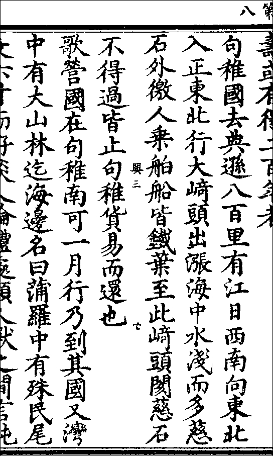
Even though the Nanshu Ibutsushi by Banshin also has been lost, the context of the quote has been recorded in the ancient sutra of Shintan-kei (Mdr. Shendan-jing) and Taihei-gyoran (Mdr. Taiping-yulan). Professor Jao and professor Chen have reconstructed roughly the original text to read as follows:
「句稚國、去典遜八百里、有江口、西南向。東北行、極大崎頭、出漲海。水淺而多磁石、外徼人乘大舶、皆以鐵葉錮之、至此崎頭、礙磁石不得過。皆止句稚、貨易而還也。」
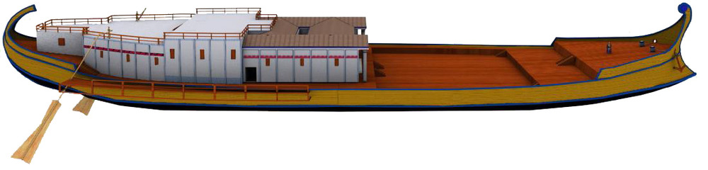
This paragraph can be summarized as follows. Cargo ships sailed from the two countries of Kuchi (Mdr. Juzhi) and Tenson (Mdr. Dianxun) west of the Malay Peninsula, passed the Malacca Strait, and reached Chokai (Mdr. Zhang Hai), roughly where today's South China Sea is. In Chokai (Mdr. Zhang Hai), the ocean was shallow and full of reefs. Because these foreign vessels were ironclad and they sank deep into the water, they could not pass through the area and had to dock on the west coast of the Malay Peninsula. Once the cargoes were traded, the ships returned westward. (Please see the thesis of professor Jao and professor Chen for specific verifications.)
The message from this paragraph points to the fact that foreign ironclad ships already tried to enter the South China Sea in the ancient time and encountered a lot of reefs. As ironclad ships were advanced inventions, they were most likely owned by large empires such as the Persian Empire, the Ancient Greece, or the Roman Empire. Two well-known ironclad vessels that belonged to the Roman tyrant, Caligula, were believed to have sunk to the bottom of the Lake Nemi at the outskirts of Rome. The efforts to recover the sunk vessels continued for five hundred years since the medieval times. In 1931, as ordered by Italy's prime minister Mussolini, the sunk vessels were finally lifted from the bottom of the lake and placed in the museum. These vessels were again embroiled in wars later and burned.

Taihei-gyoran (Mdr. Taiping-yulan), Volume 790, Entry on Kuchi (Mdr. Juzhi). Hou Sujou(Mdr. Bao Chong Cheng) edition, the 23rd year of the rein of the Kakei (Mdr. Jiaqing) Emperor, a screenshot from the web site of the Japanese National Diet Library.
As for China, there has been no record in ancient history of any large ironclad vessels. Since the Nanshu Ibutsushi (Mdr. Nanzhou Yiwuzhi) referenced "large foreign vessels were ironclad," the premise was that there were no domestic ironclad vessels in China at the time. This reference was originated from the geographical information about the South China Sea that was brought about by the foreigners from faraway places. Who first discovered the South China Sea? The credit should naturally be attributed to people in advanced western civilizations, contrary to the claim made by the Chinese government.
It is brazen for the Chinese government to claim this historical reference as iron proof that the Eastern Kan (Mdr. Han) Empire discovered the South China Sea islands, and to even blatantly tout their victimhood and the restraint they exerted in front of all the foreign dignitaries. Neither Japan nor the U.S. rebutted, possibly because they had not examined these fabricated historical details. Fortunately, even though the Ministry of Foreign Affairs of the Republic of China has arbitrarily drawn the "11-dash line," it has not been so brazen as to boast of the claim. This historical reference to large ironclad vessels could provide the future president Tsai Ing-Wen with some wiggle room.
Scholars in Taiwan are well trained in Sinology, which is unmatched by us. Now is a perfect time for these professors to accomplish a great deal, debunk lies, and contribute to the peace of the East Asia. Yet, the president Ma Ying-Jeou proposed a slogan of "Joint Development" in the "South China Sea Initiative." Recently, he also met with the president Xi Jinping in person, which really treated China with undeserved respect and would only create an impression that Taiwan echoes China's plan to claim sovereignty over the South China Sea.
China's sovereignty claim to the Senkakus (or Chogyo-dai, Mdr. Diaoyu-tai) in the East China Sea is also based on a fabricated historical reference. The marine navigation manual, "Sailing Downwind"(Junpu sousou, Mdr. Shunfeng xaingsong), which was claimed to be written in 1403 was actually written after 1573 and, therefore, was not the earliest historical reference. In 1461, the "Min (Mdr. Ming) Empire Unification Record"(Daimin ittoushi, Mdr. Daming yitongzhi) described that the empire's border was along the continental coastline and thus was far away from the Senkakus. The earliest among other literature, "Ryukyu Mission Chronicle"(Shi Ryukyu roku, Mdr. ShiLiuqiu lu), recorded in 1534 that the appointed envoy, Chin Kan (Mdr. Chen Kan), was escorted by the Ryukyuans when navigating through the sea of the Chogyo-sho Islands (or Senkakus, Mdr. Diaoyu-yu). In 1683, the boundary of Chugai (Mdr. Zhongwai —intermal and external) was not the boundary separating China from the other countries, but rather the internal and external border of the Ryukyu. The local records in Taiwan later noted “Chogyo-dai (Mdr. Diaoyu-tai) behind the mountain", which actually referred to a different Chogyo-dai (Mdr. Diaoyu-tai). These examples have demonstrated that historical truths can be easily uncovered through detailed verifications.
For several years now, it's been clear that China has been plotting to break the first island chain and to dominate the west Pacific region. The first island chain spans Japan, the Ryukyu islands, Taiwan, Philippines, Malaysia, and Vietnam. There have been many signals of an increasing concern by Japan and the U.S. over a possible breach of the island chain at Taiwan. I believe, if Taiwan makes it clear that Taiwan is a member of the camp that guards the island chain and fights against the hegemony, it will benefit the island chain immensely. The Ministry of Foreign Affairs of Taiwan could well use this as a bargaining chip to exchange for an elevated international status, and could even request Japan and the U.S. to recognize its independence. Without this bargaining chip, the U.S. may not necessarily cater to Taiwan's needs, either.
If the government of Taiwan colludes with the People's Republic of China to fabricate histories and eventually the People's Liberation Army successfully occupies the Senkakus, will that outcome benefit or hurt Taiwan? By that time, if China would also have successfully obtained sovereignty over the South China Sea, they will further encroach upon Taiwan by occupying three quarters of the surrounding waters of Taiwan. Taiwan's days will most certainly be numbered. Unarguably, this outcome will hurt and not benefit Taiwan. For Japan and the U.S., any gap near the Senkakus will cause seismic change in the global balance of power and an immediate collapse of the peace in the East Asia. Are Taiwanese really going to choose to surrender to the power of dictatorship?
P.S. The statement made by China's ambassador to the U.S., Cui Tiankai, that "America didn't even exist back then" has truly shown his arrogance and lack in introspection. When the U.S. announced the "Declaration of Independence" in 1776, where was the People's Republic of China? Looking at the culture alone, the U.S. has inherited the profound traditions of the native Americans, Greeks, Romans, and Europians. The tradition of Greeks can be traced further back to the Egyptian and Babylonian cultures which have an far longer history than our Kan (Mdr. Han) civilization. When the cuneiform characters were invented, the Kanji (Mdr. Hanzi) characters did not even exist.
The Caligula's ancient vessel from the bottom of the Lake Nemi near Rome (copied drawing), a screenshot from the Wikipedia, the copyright has been disclosed.
.
Title: Here Comes the False History Again! Debunking the Fallacy That "China Discovered South China Sea Islands Two Thousand Years Ago"
Author: Ishiwi Nozomu (Associate Professor of Nagasaki Junshin Catholic University)
Media: Taiwan People News http://www.peoplenews.tw/news/e226b0f0-698c-48c7-b914-17da65230fe4
Time: 2015-12-22 12:25 p. m.
Japanese translation : http://senkaku.blog.jp/2016040257697412.html
As the 2016 presidential election fast approaches, people have become more concerned about how Ms. Tsai Ing-Wen, once elected, will decide on the issue of the South China Sea. First, let's take a look at the claim made constantly by the chairman Xi Jinping that China has been ruling the South China Sea since the ancient time. How far back in the history should this "ancient time" be traced?
In June 2014, a general of the People's Liberation Army proclaimed at an international conference that China's sovereignty over the South China Sea could be traced back to two thousand years ago. A journalist of the Yomiuri Shimbun newspaper then asked me: what was the historical basis for such a wild claim? I replied that I had not verified the claim, but I was confident that the claim was bogus—whenever China wants to promote itself as glorious culture and history, they make bogus claims. On August 6th this year when Wang Yi, the Foreign Minister of China, attended a conference of foreign ministers in Southeastern Asia, he once again claimed, "China discovered and named the South China Sea islands two thousand years ago. Even as China's right has been threatened in recent years, the country has exerted a lot of restraint."
Later on, the American aircraft carrier patrolled the South China Sea. When interviewed by the CNN, Cui Tiankai, the Chinese Ambassador to the United States, mocked the U.S. by showing off China's long history, "America didn't even exist back then." That statement rendered the CNN reporter speechless.
After Wang Yi's claim, I looked up the website of China's Ministry of Foreign Affairs and found that the reference of "two thousand years" was originated from the mentioning of Chokai-Kitou (Mdr. Zhanghai-Qitou *)—that is, the reef in the South China Sea—in the Ibutsu-shi (Mdr. Yiwu-zhi —"Ibutsu" refers to foreign culture or foreigners) by Youfu (Mdr. Yangfu) in Eastern Kan (Mdr. Han) Empire. However, according to the research conducted by professors such as Jao Tsung-I, Chen Jia-Rong, and Wu Yong-Zhang, the quote was not originated from the Ibutsu-shi in Eastern Kan Empire, but rather in the lost Nanshu Ibutsushi (Mdr. Nanzhou Yiwuzhi—"Nanshu" refers to south area) by Banshin (Mdr. Wanzhen) in the Go (Mdr. Wu) Kingdom during Three Kingdoms period. The Three Kingdoms period occurred two hundred years later than the Eastern Kan Empire.
* Mdr. : Chinese Mandarin pronounciation. The left one is based on Sino-Japanese one.
The Ibutsushi by Youfu in Eastern Kan Empire has been lost. Could it be possible that the quote in the Ibutsushi by Youfu is the same as the one in the Nanshu Ibutsushi (Mdr. Nanzhou Yiwuzhi)? So far, there has been no evidence to prove that the two quotes are the same. Thus, any prudent historian should not casually move up the timeframe by two hundred years.
Seitou-douzou (Mdr. Zhengtong-daozang), Book 582, Sutra Shintan-kei (Mdr. Shendan-jing), Page 8, a screen shot from the Chinese Text Project.
Yet, the timeframe is not critical. The key is that the context of the quote completely rejects China's claim that "Chinese discovered and named the South China Sea islands."
Even though the Nanshu Ibutsushi by Banshin also has been lost, the context of the quote has been recorded in the ancient sutra of Shintan-kei (Mdr. Shendan-jing) and Taihei-gyoran (Mdr. Taiping-yulan). Professor Jao and professor Chen have reconstructed roughly the original text to read as follows:
「句稚國、去典遜八百里、有江口、西南向。東北行、極大崎頭、出漲海。水淺而多磁石、外徼人乘大舶、皆以鐵葉錮之、至此崎頭、礙磁石不得過。皆止句稚、貨易而還也。」
This paragraph can be summarized as follows. Cargo ships sailed from the two countries of Kuchi (Mdr. Juzhi) and Tenson (Mdr. Dianxun) west of the Malay Peninsula, passed the Malacca Strait, and reached Chokai (Mdr. Zhang Hai), roughly where today's South China Sea is. In Chokai (Mdr. Zhang Hai), the ocean was shallow and full of reefs. Because these foreign vessels were ironclad and they sank deep into the water, they could not pass through the area and had to dock on the west coast of the Malay Peninsula. Once the cargoes were traded, the ships returned westward. (Please see the thesis of professor Jao and professor Chen for specific verifications.)
The message from this paragraph points to the fact that foreign ironclad ships already tried to enter the South China Sea in the ancient time and encountered a lot of reefs. As ironclad ships were advanced inventions, they were most likely owned by large empires such as the Persian Empire, the Ancient Greece, or the Roman Empire. Two well-known ironclad vessels that belonged to the Roman tyrant, Caligula, were believed to have sunk to the bottom of the Lake Nemi at the outskirts of Rome. The efforts to recover the sunk vessels continued for five hundred years since the medieval times. In 1931, as ordered by Italy's prime minister Mussolini, the sunk vessels were finally lifted from the bottom of the lake and placed in the museum. These vessels were again embroiled in wars later and burned.

Taihei-gyoran (Mdr. Taiping-yulan), Volume 790, Entry on Kuchi (Mdr. Juzhi). Hou Sujou(Mdr. Bao Chong Cheng) edition, the 23rd year of the rein of the Kakei (Mdr. Jiaqing) Emperor, a screenshot from the web site of the Japanese National Diet Library.
As for China, there has been no record in ancient history of any large ironclad vessels. Since the Nanshu Ibutsushi (Mdr. Nanzhou Yiwuzhi) referenced "large foreign vessels were ironclad," the premise was that there were no domestic ironclad vessels in China at the time. This reference was originated from the geographical information about the South China Sea that was brought about by the foreigners from faraway places. Who first discovered the South China Sea? The credit should naturally be attributed to people in advanced western civilizations, contrary to the claim made by the Chinese government.
It is brazen for the Chinese government to claim this historical reference as iron proof that the Eastern Kan (Mdr. Han) Empire discovered the South China Sea islands, and to even blatantly tout their victimhood and the restraint they exerted in front of all the foreign dignitaries. Neither Japan nor the U.S. rebutted, possibly because they had not examined these fabricated historical details. Fortunately, even though the Ministry of Foreign Affairs of the Republic of China has arbitrarily drawn the "11-dash line," it has not been so brazen as to boast of the claim. This historical reference to large ironclad vessels could provide the future president Tsai Ing-Wen with some wiggle room.
Scholars in Taiwan are well trained in Sinology, which is unmatched by us. Now is a perfect time for these professors to accomplish a great deal, debunk lies, and contribute to the peace of the East Asia. Yet, the president Ma Ying-Jeou proposed a slogan of "Joint Development" in the "South China Sea Initiative." Recently, he also met with the president Xi Jinping in person, which really treated China with undeserved respect and would only create an impression that Taiwan echoes China's plan to claim sovereignty over the South China Sea.
China's sovereignty claim to the Senkakus (or Chogyo-dai, Mdr. Diaoyu-tai) in the East China Sea is also based on a fabricated historical reference. The marine navigation manual, "Sailing Downwind"(Junpu sousou, Mdr. Shunfeng xaingsong), which was claimed to be written in 1403 was actually written after 1573 and, therefore, was not the earliest historical reference. In 1461, the "Min (Mdr. Ming) Empire Unification Record"(Daimin ittoushi, Mdr. Daming yitongzhi) described that the empire's border was along the continental coastline and thus was far away from the Senkakus. The earliest among other literature, "Ryukyu Mission Chronicle"(Shi Ryukyu roku, Mdr. ShiLiuqiu lu), recorded in 1534 that the appointed envoy, Chin Kan (Mdr. Chen Kan), was escorted by the Ryukyuans when navigating through the sea of the Chogyo-sho Islands (or Senkakus, Mdr. Diaoyu-yu). In 1683, the boundary of Chugai (Mdr. Zhongwai —intermal and external) was not the boundary separating China from the other countries, but rather the internal and external border of the Ryukyu. The local records in Taiwan later noted “Chogyo-dai (Mdr. Diaoyu-tai) behind the mountain", which actually referred to a different Chogyo-dai (Mdr. Diaoyu-tai). These examples have demonstrated that historical truths can be easily uncovered through detailed verifications.
For several years now, it's been clear that China has been plotting to break the first island chain and to dominate the west Pacific region. The first island chain spans Japan, the Ryukyu islands, Taiwan, Philippines, Malaysia, and Vietnam. There have been many signals of an increasing concern by Japan and the U.S. over a possible breach of the island chain at Taiwan. I believe, if Taiwan makes it clear that Taiwan is a member of the camp that guards the island chain and fights against the hegemony, it will benefit the island chain immensely. The Ministry of Foreign Affairs of Taiwan could well use this as a bargaining chip to exchange for an elevated international status, and could even request Japan and the U.S. to recognize its independence. Without this bargaining chip, the U.S. may not necessarily cater to Taiwan's needs, either.
If the government of Taiwan colludes with the People's Republic of China to fabricate histories and eventually the People's Liberation Army successfully occupies the Senkakus, will that outcome benefit or hurt Taiwan? By that time, if China would also have successfully obtained sovereignty over the South China Sea, they will further encroach upon Taiwan by occupying three quarters of the surrounding waters of Taiwan. Taiwan's days will most certainly be numbered. Unarguably, this outcome will hurt and not benefit Taiwan. For Japan and the U.S., any gap near the Senkakus will cause seismic change in the global balance of power and an immediate collapse of the peace in the East Asia. Are Taiwanese really going to choose to surrender to the power of dictatorship?
P.S. The statement made by China's ambassador to the U.S., Cui Tiankai, that "America didn't even exist back then" has truly shown his arrogance and lack in introspection. When the U.S. announced the "Declaration of Independence" in 1776, where was the People's Republic of China? Looking at the culture alone, the U.S. has inherited the profound traditions of the native Americans, Greeks, Romans, and Europians. The tradition of Greeks can be traced further back to the Egyptian and Babylonian cultures which have an far longer history than our Kan (Mdr. Han) civilization. When the cuneiform characters were invented, the Kanji (Mdr. Hanzi) characters did not even exist.

The Caligula's ancient vessel from the bottom of the Lake Nemi near Rome (copied drawing), a screenshot from the Wikipedia, the copyright has been disclosed.
.

Tribunal Did Not Refute Hositorical Latitude of Scarborough Shoal
(translation) The Arbitration Tribunal Did Not Refute the Assertion of Latitude Measurement of Gen (Mdr. Yuan *) Empire but Condemn “The Taiwan Authorities of China”
by ISHIWI, Nozomu
Associate Professor of Nagasaki Junshin Catholic University,
& Research Specialist (concurrent) of Investigation Business Unit consigned by Office of Policy Planning Coordination on Territory and Sovereignty
* The original Kanji terms are translated according to the pronunciations of Japanese kanji, and herein accompanied with pronunciations in corresponding Mandarin.
The original Chinese version, in the internet site of Storm Media Group, see link:
http://www.storm.mg/article/144427
Time: 2016-7-23 06:40 a. m.
Japanese translation: http://senkaku.blog.jp/2016091565883977.html
The original Chinese version, in the internet site of Storm Media Group, see link:
http://www.storm.mg/article/144427
Time: 2016-7-23 06:40 a. m.
Japanese translation: http://senkaku.blog.jp/2016091565883977.html
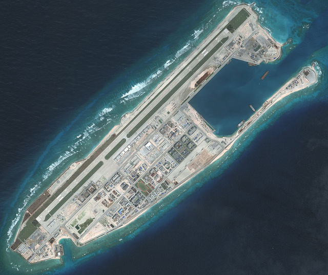
Upon the award of South China Sea Arbitration as dated July 12th, Taiwan was concerned with how Itu Aba Island (Mdr. Taiping Island) would be defined – an island or a reef, while the press abroad gave more attention to whether or not the historic rights of the People’s Republic of China were denied. At the first glance of the news title, I was delighted as I thought there was someone brilliant in the court having good eyesight and daring to unmask the country’s false history. A few hours later, a Japanese professor in the UK sent me the website of the original verdict, and I myself also sourced the shortened version in Mandarin from Liberty Times (Taiwan).
After reading them roughly, my delight vanished in despair. The “nine-dash line” was denied in the verdict many times, however, the words were as simple as “the historic rights are contradictory with international laws”, or “the nine-dash line has no legal effect”. None of them directly gave a head-on blow on the nine-dash line. The tribunal is too cautious, as I see. They winced in front of the struggle for the truth of history. They missed the best opportunity to shock the “fake antique shop”. Owing to the tribunal’s evasion, the People's Republic of China will tell more lies more unscrupulously.
China Sea Directory, published by British Navy in the 19th century, was frequently cited in the verdict, powerfully denying the false history. However, nearly all the Kanbun* documents and materials related to the nine-dash line were ignored, which are only indirectly mentioned once in Note 840 on Page 309 of the original English version.
http://thediplomat.com/wp-content/uploads/2016/07/thediplomat_2016-07-12_09-15-50.pdf
Cited from an English declaration of the Chinese Embassy in Manila.
http://ph.china-embassy.org/eng/zt/nhwt/t941672.htm
The Chinese Embassy claimed that Chinese astronomical surveys and fishery in Scarborough Shoal has dated back to Gen (Mdr. Yuan) Empire and continuously developed till now, which was contradicted by the verdict on Page 311 as "The Tribunal’s conclusions with respect to traditional fishing are thus independent of the question of sovereignty."
It is absolutely right that fishery is irrelevant to sovereignty, but the fraud of latitude measurement of Gen Empire was totally unexposed. Is that to say they only discuss those English materials that are legible and totally avoid Kanbun* materials because of their ignorance of Kanbun? This equals a total denial of the Kanji culture, not just a denial of the Peoples Rupublic's claim.
* Kanbun: Mdr. Hanwen, or literal Chinese, similar to Latin, or literal Italian, in Europe.
The history materials of astronomical surveys refer to Shikai Sokken (Mdr. Si-hai-ce-yan, Surveying Shores on Four Directions), Volume 3 of Shosho-tsuko (Mdr. Shang-shu-tong-kao) by Kou Chinsei (Mdr. Huang Zhencheng) of Gen Empire, which was later included in Tenmonshi (Mdr. Tienwenzhi, Astronomy Journal) of Genshi (Mdr. Yuan-shi, or Official History of Gen Empire). Gen Empire highly valued Islamic science. Kaku Shukei (Mdr. Guo Shoujing) the renowned astronomer was delegated by Kublai to measure latitude from south to north. He obtained a latitude 15° north in "South Sea" (see the photocopy). 15° north is exactly the latitude of Scarborough Shoal, and thereby the People's Republic of China asserted that the “South Sea” therein refers to Scarborough Shoal. The fact is that Kaku Shukei only measured the latitude without the longitude. Middle Vietnam is also on the same latitude. How dare the People's Republic to say that place (15° north) is Scarborough Shoal on the coastline of Philippines! This fallacy has been challenged by many experts. I have something new here to add.
Ancient Observatory built in Pekin under the guidance of missionary. extracted from Illustrations of China and its people, J. Thomson, published by "China Through Western Eyes", 1873

Leave aside the accuracy of Kaku Shukei’s measurement, let’s first align the clue of this story. 360-degree Circumference was invented by ancient Babylonians, and flowed into Tou (Mdr. Tang) Empire via India. Many ancient astronomical books mentioned that a Tou monk called Ichigyou (Mdr. Yixing) was skillful in Indian calendar and measured latitude all under heaven. He plotted the first Sanga Nanboku Ryoukai Zu (Mdr. Shanhe Nanbei Liangjie Tu, Map of Two Borders, Mountains and Rivers, South and North). That is the first national map. With his intention of surpassing Monk Ichigyou, Kaku Shukei (Mdr. Guo Shoujing) re-measured the country to manifest the vastness and civilization prosperity of Gen Empire.
The Tou Monk Ichigyou once sent someone to Rin-yu (Mdr. Lin-yi, today’s Vietnam) to obtain a latitude 17° north, a well-known figure representing the extreme south. By Gen Empire, the figure was still inscribed on Gyogi (Mdr. Yang-yi), a national astronomical instrument, noted as “Seventeen, extremely shallow, Rin-yu territory”. The extremely shallow means low latitude. Later in Tenmonshi of Genshi, it was rewritten as “Fifteen, extremely shallow, Rin-yu territory”.
Why change seventeen to fifteen? Obviously the 15° latitude of Rin-yu by Kaku Shukei was collected into Genshi, inheriting Ichigyou’s achievement. The compilation of Genshi was conducted by Souren (Mdr. Songlian) and other celebrities of that time, as invited by Emperor Koubu (Mdr. Hongwu) of Min (Mdr. Ming) Empire, and is finished soon after the founding of Min Empire. It almost equals a contemporary record of Gen Empire. For this we can say Souren among others also held that the 15° measured by Kaku Shukei was in Rin-yu, the same as Ichigyou, not in Scarborough Shoal. Crossing the ocean to Scarborough Shoal would have been an unprecedentedly magnificent feat far more significant than Ichigyou’s measurement. Was there any possibility that the editors of Genshi would mistake Scarborough Shoal for Rin-yu?
Genshi is the official works of Min Empire. Suppose it intended to deny the glorious achievement of Gen Empire, there would be two common methods. One was to completely erase the fact of Kaku Shukei’s measurement by skimming it over or even not saying a single word about it. The other one was to reproach Kaku Shukei for defecting abroad and spreading rumors. The editors of Genshi chose neither of these two skilfull methods, but stealthily substituted Rin-yu for Scarborough Shoal, which would be a clumsy method failing to blot out Kaku’s effort. Thus the above assumption is really a fallacy, don’t you think so? Thus the above assumption is really a fallacy. The fact is the point of measurement is located in Rin-yu, not in Scarborough Shoal. China’s lies betray themselves. What a pity that the marine tribunal failed to unmask them, indulging the country to dismiss the award and go on claiming their two-thousand year jurisdiction over South China Sea.
(two-thousand year jurisdiction : http://senkaku.blog.jp/2016032257037201.html )
Tenmonshi (Astronomy Journal) of Genshi (Official History of Gen Empire),
Kouki (Mdr. Kangxi) Period version, owned by Keio University
Kouki (Mdr. Kangxi) Period version, owned by Keio University

Undeniably, Kaku Shukei is an excellent scientist, but the 360-degree Circumference is an import. We needn’t say Kaku Shukei as highly as People's Republic, and the accuracy of his measurement is also arguable. On the first six measurement points, the angle for Polaris’ rise (i.e. North latitude) are 15°, 25°, 35°, 45°, 55° and 65° (See the photocopy). That is to say, Kaku knows the latitude before deciding the measurement points. Thus the accuracy of the angle is questionable. The most obvious is that 25° was described as “no shadow at summer solstice”. At Summer solstice, places without sundial’s shadows are all above the Tropic of Cancer, i.e. 23.5° north. How can it be 25°? Obviously, the figure was rounded and correspondingly, the measurement was not so accurate. Similarly, there should be some deviations from the 15° measurement in "South Sea". It should be within the range from 14° to 16°, so it cannot be determined as the 15° of Scarborough Shoal.
In view of the inaccuracy, we have to review the following size of the sundial shadow. Gakudai (Mdr. Yuetai) at 35° north is also named Taigakudai (Mdr. Taiyuetai), where the shadow of the sundial at summer solstice is 1.48 shaku (Mdr. chi, Kanji units of measurement, 1 shaku ≈ 30cm). The ancient shadow of the sundial is 8 shaku. Converted by trigonometry, 1.48 shaku is equivalent to a latitude slightly less than 34°.
Taigakudai is the traditional site for erecting a sundial. The Great Cebtral Kingdom ideological believed that it is the center of the earth, so it is more important than any other sundial point and the measurement at Taigakudai should be much more careful. Where is it? Tenmonshi (Astronomy Journal) of Shin-Toujo (Mdr. Xin-tang-shu, Official History of Tou Empire) writes, “From Katsu (Mdr. Hua) county, walk 199 Ri (Mdr. Li, about 500 meter) southward to Taigakudai, furhter 168 Ri southward to Fukou (Mdr. Fugou) county, another 160 Ri southward to Jousai (Mdr. Shangcai) county. Taigakudai is in the middle of Katsu county and Fukou county, close to Kaihou (Mdr. Kaifeng) Prefecture.
With reference to modern data, Kaihou is 34°45′ north, while Fukou is slightly more than 34° north. Via the sundial, Kaku measured slightly less than 34° north for Taigakudai, which is south of Fukou. Compared with Kaihou’s latitude, there is at least a deviation of 0.5°. Thus Kaku’s measurement of the sundial shadow at summer solstice is not so accurate. Similarly, the 15-degree of "South Sea" may be between 14.5° and 15.5°. This fuzzy figure is utilized and falsely interpreted into the latitude of Scarborough Shoal, by which China robbed Philippines.

One more thing that has to be mentioned is that, according to descriptions in the Genshi text of 54 koku (Mdr. ke, a short period of time) at daylight and 46 koku at night under the size of the sundial shadow, one whole day is divided into 100 koku, the daytime is longer than the nighttime in the north, and the daytime is equal with the nighttime in the south. Peoples Republic’s experts went so far as to conclude thereby that the longitude of the "South Sea" measurement is the same as that of Scarborough Shoal. It is as easy as an exercise for pupils. What has longitude to do with the length of daytime / nighttime? The tribunal seemed indifferent. I am really in a situation between tears and laughter. Moreover, the longitude measurement became precise in the 18th century Europe, so if the longitude of Scarborough Shoal had been measured by Gen Empire, the whole history of science would be rewritten.
I’m more and more indulged in disclosing the above historic tricks. However, Taiwanese don’t care. They only concern that Itu Aba Island has been degraded to a reef. In a few days of brainstorming, Legislator Kuan Bi-ling pointed out the crux on July 13th (The day after the verdict day). She said none of the claimers for Spratly (Mdr. Nansha) Islands declared the rights for exclusive economic zones; Taiwan didn’t, either. Since Itu Aba Island had been degraded, Taiwan must continue to keep silent and the present status would not change. The tribunal also set limits on rights of other countries, and the benefits outweigh the disadvantages for Taiwanese. Actually, the most painful loss to Taiwan is being defined as “the Taiwan Authorities of China”.
(Legislator Kuan Bi-ling : https://www.youtube.com/watch?v=cWQkoa2FgGE )
Why does such a horrifying title appear in the verdict? I reckon the Tribunal is intentionally warning Taiwan not to serve as the cat’s paw of China. The tribunal focussed on the peace of South China Sea, right? The only peacebreaking power at present is the Peoples Republic of China. If Taiwan followed its step, Taiwan would become another destructive factor, which is intolerable to the tribunal. To give Taiwan a lesson, the tribunal called them “the Taiwan Authorities of China”, the same as calling Taiwan a jackal.
As the tribunal wants to keep peace, this award is doomed. According to the verdict, no islands or reefs have the right to own exclusive economic zones. In other words, no one can occupy South China Sea forcibly. It is the fairest judgment. If only Itu Aba Island and a plurality of large islands were judged as island, and all the others as reefs, the public opinion in Taiwan would naturally require the government to announce exclusive economic zones. Upon announcement, only these islands aforesaid can seize the vast sea area, leaving no space for other islands. Can this comfort other countries? No, it certainly will bring about a disastrous consequence resulting in more fierce conflicts, even armed conflicts between Taiwan and Philippines or Vietnam. Then the area will become the second or third power magazine in the world, just as Balkan in East Europe. The tribunal wouldn’t like to see this verdict become a historic blasting fuse. In a word, this verdict is the only and doomed solution to South China Sea problem.
Nevertheless, many deserted islands will be determined as reefs by this criterion. For example, Okino-torishima, as the sea area around it has no overlapping border with neighbor countries, can it be continuously determined as an island? Senkaku (or Chogyo, Mdr. Diaoyu) Islands is another example, will it be determined as a reef? A series of problems will come out. The tribunal has the awareness of such troubles; however, in consideration of the peace of South China Sea, all Spratly (Mdr. Nansha) Islands have to be determined as reefs. This move seemed risky, but there’s no other choice but seeking for desperate measure : self-trouble-shooting. Considering difficulties and determination of the tribunal, we should understand and respect the award. I forecast this award will be of historic significance and fame over time.
。

"17th-Century Document" Business Insider, Robert Johnson
Japan Says A 17th-Century Document Proves It Owns The Disputed Islands
Robert Johnson Jan 24, 2013, 7:05 AM
http://www.businessinsider.com/japan-cites-17th-century-document-proving-ownership-senkaku-islands-2013-1
http://www.businessinsider.com.au/japan-cites-17th-century-document-proving-ownership-senkaku-islands-2013-1
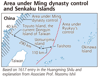
The main point of contention over the disputed East China Sea islands consuming a feud between China and Japan is simply who controlled them first.China claims to have controlled the area where the islands sit since the Ming dynasty about 600 years ago, but Japan unveiled a report calling that claim into question.
The Tokyo ‘paper Yomiuri Shimbun cites a 17th century document from a Chinese official sent to a Japanese envoy explaining the dynasty’s control ended far short of the Senkaku Islands.
From the Yomiuri:
During China’s Ming dynasty, a provincial governor told a Japanese envoy that the ocean area under the dynasty’s control ended with the Matsu Islands, now under Taiwan’s administration, and the sea beyond that was free for any nation to navigate, said Nozomu Ishii, an associate professor of Nagasaki Junshin Catholic University.
The Matsu Islands are much closer to China than the Senkaku Islands, which China claims to have controlled since the Ming dynasty about 600 years ago. At a press conference Monday, Ishii said the Chinese governor’s statement appears in “Huangming Shilu”, the official annals of the Ming dynasty.
“This historical material proves that Japan’s claim over Senkaku Islands is historically correct,” he said.
The islands called Senkaku in Japan and Diayo in China are the focus of many recent verbal exchanges and confrontations between the Japanese and Chinese military.

.
Robert Johnson Jan 24, 2013, 7:05 AM
http://www.businessinsider.com/japan-cites-17th-century-document-proving-ownership-senkaku-islands-2013-1
http://www.businessinsider.com.au/japan-cites-17th-century-document-proving-ownership-senkaku-islands-2013-1
The main point of contention over the disputed East China Sea islands consuming a feud between China and Japan is simply who controlled them first.China claims to have controlled the area where the islands sit since the Ming dynasty about 600 years ago, but Japan unveiled a report calling that claim into question.
The Tokyo ‘paper Yomiuri Shimbun cites a 17th century document from a Chinese official sent to a Japanese envoy explaining the dynasty’s control ended far short of the Senkaku Islands.
From the Yomiuri:
During China’s Ming dynasty, a provincial governor told a Japanese envoy that the ocean area under the dynasty’s control ended with the Matsu Islands, now under Taiwan’s administration, and the sea beyond that was free for any nation to navigate, said Nozomu Ishii, an associate professor of Nagasaki Junshin Catholic University.
The Matsu Islands are much closer to China than the Senkaku Islands, which China claims to have controlled since the Ming dynasty about 600 years ago. At a press conference Monday, Ishii said the Chinese governor’s statement appears in “Huangming Shilu”, the official annals of the Ming dynasty.
“This historical material proves that Japan’s claim over Senkaku Islands is historically correct,” he said.
The islands called Senkaku in Japan and Diayo in China are the focus of many recent verbal exchanges and confrontations between the Japanese and Chinese military.
.

White Papers of Vietnam (1981) THE HOANG SA AND TRUONG SA ARCHIPELAGOES: VIETNAMESE TERRITORIES
http://paracelspratlyislands.blogspot.jp/2008/01/white-papers-of-socialist-republic-of_11.html
White Papers of Vietnam (1981)
THE HOANG SA AND TRUONG SA ARCHIPELAGOES : VIETNAMESE TERRITORIES
MINISTRY OF FOREIGN AFFAIRS SOCIALIST REPUBLIC OF VIETNAM
1981
(黃沙群島和長沙群島ーー越南領土)
CONTENTS
Part I — The Vietnamese state's long standing and uninterrupted sovereigntyover the Hoang Sa and Truong Sa archipelagoes
1. Vietnam's historical sovereignty over the two archipelagoes of Hoang Saand Truong Sa
2. France carried on the exercise of sovereignty over the archipelagoes ofHoang Sa and Truong Sa on behalf of the Vietnamese state
3. The defence and exercise of Vietnam's sovereignty over the archipelagoesof Hoang Sa and Truong Sa since the end of the Second World War
Supplements
Part II — The Hoang Sa and Truong Sa archipelagoes have never beenChinese territories
1. On the so-called "discovery" and "exploitation" by the Chinese people 292. On the so-called "jurisdiction" excercised by Chinese dynasties 303. A new allegation from Peking: Vietnam's Hoang Sa and Truong Sa andChina's "Xisha" and "Nansha" are not the same 33
Supplements
Conclusion
-----------------------------
FOREWORD
For decades now, the Chinese authorities have nurtured ambitions overthe two Vietnamese archipelagoes of Hoang Sa (i.e Paracels) and Truong Sa(i.e. Spratley or Spratly). which are called "Xisha" and "Nansha" by the Chinese.The Chinese authorities have been searching for testimonies in ancient booksto prove that their ancestors had discovered and exploited these two archipelagoeslong ago. But most embarrassingly they have failed to bring out when the Chinesestate began to take possession of "Xisha" and "Nansha" and how this stateexercised its sovereignty over them.In the booklet Vietnam's sovereignty over the Hoang Sa and Truong Saarchipelagoes published in September 1979, the Ministry of Foreign Affairs of theSocialist Republic of Vietnam has made public a number of historical documents and juridical evidence which unmistakably prove that:— Vietnam has been in possession of the two archipelagoes of Hoang Sa andTruong Sa since the time when no other countries claimed sovereignty over them;— Vietnam has been continuously exercising its sovereignty over these twoarchipelagoes ever since.In the present booklet, the views of the Socialist Republic of Vietnam willbe briefly presented to prove once again that the Hoang Sa and Truong Sa archipelagoeshave for a long and uninterrupted period of time been part and parcelof Vietnamese territories, that the Chinese claim over these two archipelagoes- iswithout juridical grounds and that the Chinese occupation of the Hoang Sa archipelagoby force is an act of aggression.
PART I
THE VIETNAMESE STATE'S LONG STANDING AND UNINTERRUPTED SOVEREIGNTY OVER THE HOANG SAAND TRUONG SA ARCHIPELAGOES
It is necessary, first of all, to make clear that Hoang Sa and Truong Sa are twoarchipelagoes lying off the Vietnamese coast in the East Sea (1); the nearest point of Hoang Sa is about 120 nautical miles from a coastal island called Re, and about 170 nautical miles east of Da Nang Harbour ; while Truong Sa's nearest point is about 250 nautical miles east of Cam Ranh Bay.
In ancient times, the knowledge primarily acquired by navigators about Hoang Sa andTruong Sa was still vague; they only knew that in this vast sea area navigation wasdangerous because there were submerged rocks. In those days, the Vietnamese called the area Bai Cat Vang (Golden Sandbank) or Hoang Sa, or Van Ly Hoang Sa, or Dai Truong Sa or Van Ly Truong Sa as shown in ancient Vietnamese books and maps. Almost all Western navigators' maps between the 16th and 18th centuries marked these two groups of islands under one single name : Pracel or Parcel or Paracels (2). The above-mentioned maps generally defined the Pracel area as situated in the middle of the East Sea, east of Vietnam, off the Vietnamese coastal islands.(3)
Following the progress made in science and navigation, later on it became possible todistinguish the two archipelagoes : the Hoang Sa and the Truong Sa. The archipelagoes specified as Paracels and Spratley or Spratly in present-dayinternational maritime maps are precisely the two Vietnamese archipelagoes of Hoang Sa and Truong Sa. The appellations of "Xisha" and "Nansha" were put forth by the Chinese expansionists some decades ago to promote their scheme of land-grabbing.(4)
1. VIETNAM'S HISTORICAL SOVEREIGNTY OVER THE TWO ARCHIPELAGOES OF HOANG SA AND TRUONG SA
Long ago the Vietnamese people discovered the archipelagoes of Hoang Sa andTruong Sa; the Vietnamese state has occupied them and exercised its sovereigntyoverthem ever since. Ancient Vietnamese geographical books and maps record clearly that Bai Cat Vang (Golden Sandbank), otherwise called Hoang Sa, or Van Ly Hoang Sa, or Dai Truong Sa, or Van Ly Truong Sa, had long since been a Vietnamese territory.Toan Tap Thien Nam Tu Chi Lo Do Thu (Route Map from the Capital to theFour Directions), a Vietnamese atlas compiled and drawn by Do Ba, alias CongDao, in the 17th century, in its notes attached to the map of Quang Ngai district,Quang Nam province, discribed "an elongated sandbank lying in mid-sea knownas the Golden Sandbank". "Every year, in the last month of winter, the Nguyens (5) would send eighteen boats to Bai Cat Vang to retrieve ship-wrecked cargoes, which included jewels, coins, arms and ammunition" (6).
In Giap Ngo Binh Nam Do, a map of Southern Vietnam, drawn in 1774 bythe Duke of Doan, Bui The Dat, Bai Cat Vang was also specified as part of Vietnamese territory (7).In Phu Bien Tap Luc, a book written by the Scholar Le Qui Don (1726-1784)on the history, geography, and administration of Dang Trong (present-day SouthernVietnam) under the Nguyen Lords (1558-1775), Hoang Sa and Truong Sa islandswere defined as belonging to Quang Ngai district: "In Quang Ngai district, off the coast of An Vinh village (8), Binh Son subdistrict, there is an island called Cu Lao Re stretching over 30 dams (9). The Tu Chinh settlement, as it is called, has been established here and the people there grow beans. It takes half a day by boat to get there. Further off, there are Dai Truong Sa islands where sea products and ship-wrecked cargoes are available to be collected by the Hoang Sa detachment. It takes three days and nights to reach there by boat. They are near an area called Bac Hai .Dai Nam Nhat Thong Toan Do, the atlas of Vietnam, completed circa 1838clearly set Hoang Sa—Van Li Truong Sa—as part of Vietnamese territory (10).In Dai Nam Nhat Thong Chi, a geographical book on Vietnam whose compilationwas completed in 1882 (11) by the National Institute of History under theNguyen dynasty (1802-1945), Hoang Sa was defined as part of the Vietnamese territory belonging to Quang Ngai province. In its topographical description of QuangNgai the book describes :
"To the east (of Quang Ngai), there exist sand islands — the Hoang Sa... To thewest, a mountainous region stands like a bulwark. The province borders on BinhDinh in the South at Ben Da Pass, and on Quang Nam in the North where Sa ThoGorge marks the provincial boundary".
Many Western navigators and missionaries in past centuries confirmed HoangSa as part of Vietnamese territory. A Western priest during his trip from France to China on board the Amphitrite wrote in one of his letters: "Paracel is an archipelago belonging to the Kingdom of Annam" (12).
In a supplementary note to his Memoire sur la Cochinchine (13) J.B. Chaigneau,Emperor Gia Long's adviser, in about 1820 wrote : "Cochinchina whose king has proclaimed himself Emperor consists of Cochinchina proper (14) and Tonkin (15) and a number of inhabited off-shore islands and the archipelago of Paracel formed by several uninhabited islets, reefs and rocks...(16) Bishop J.L. Taberd, in his Note on Geography of Cochinchina published in 1837, described Pracel or Paracels as part of Cochinchina's territory and related that the Cochinchinese called Pracel or Paracels by the name of "Cat vang" (17). In An Nam Dai Quoc Hoa Do (Map of Annam) published in 1838, he delineated part of Paracels with a note that "Paracels or Cat Vang" lie in the middle of the sea beyond the coastal islands of Central Vietnam, in the area presently known as the Hoang Sa archipelago (18). In an article entitled Geography of the Cochinchinese Empire (19) published in 1849, Gutzlaff defined Paracels as belonging to Vietnam and also used the Vietnamese designation 'Kat Vang' in accompanying notes.
As the sovereign, the Vietnamese feudal state in past centuries had conductedmany geographical and resources surveys of the two archipelagoes of Hoang Saand Truong Sa. The Results of those surveys have been recorded in Vietnameseliterature on geography and history published since the 17th century.This can be read in Toan Tap Thien Nam Tu Chi Lo Do Thu (17th century) :"In the middle of the sea emerges an elongated sandbank called Bai Cat Vang,about 400 dams in length and 20 dams in width, facing the coastline between the(12) J.Y.C.'s quotation in his article "Mystére des atolls—journal de voyage aux Paracels" printed in the weekly "Indochine", issues of July 3, 10 and 17, 1941. The Kingdom of Annam was the name of Vietnam in those days.(13), (14) Cochinchine (French) or Cochinchina (English) used in some Western documents, depending on the context indicated : a) Vietnam as a nation at the time ; or b) the Southern Vietnam provinces.
Harbour of Dai Chiem (20) and that of Sa Vinh (2l), During the South-West monsoon,foreign comercial ships sailing along the coast side of the sandbank wouldoften be flown off course and run aground there. The same thing would happento those sailing on the other side of the sandbank during the North-East monsoon.Men on board the wrecked ships often starved and wrecked cargoes amassedthere" (22). In Phu Bien Tap Luc (1776), Le Qui Don wrote : "The village of An Vinh, Binh Son sub-district, Quang Ngai district, lies close by the sea. To the northeast of this village, there is a cluster of islands composed of over 130 islets and rocks. It may take a day or just a few watches to sail from one islet to another. On some islands there is fresh water. A flat and large strip of yellow sand stretching over30 dams distinguishes itself among these islands. Here the water is crystal clear.The islands abound with swallows' nests and swarms with thousands upon thousandsof birds of various species which remain indifferent to the sight of men(23). Strange things lie on the beach. Of the mollusks there are conches whose sizeis of a bed-mattress, whose pearls are opaque and whose shells can be cut intosmall plaques or baked into lime for house building. There are also whelks whoseshells can be used as mother-of-pearl for inlaid work. Conches and whelks andother mollusks can also be salted or cooked for food... Foreign vessels hit by stormsare often wrecked on these islets".
Dai Nam Thuc Luc Tien Bien, a book on the history of the Nguyen Lords completedby the National Institute of History under the Nguyen dynasty in 1884, similarly wrote : "Far out in the middle of the sea beyond the coast of An Vinh village, Binh Son subdistrict, Quang Ngai district there are over 130 sandbanks separated by sea distances of a full day's voyage or just a few watches' and scattered on a length of several thousand dams, hence the popular designation of Van Ly Hoang Sa. Fresh water springs are found on many sandbanks. Sea products there include seacucumbers, conches, tortoises, turtles, etc."
For its part, Dai Nam Nhat Thong Chi (1882) also wrote :"The Hoang Sa islands stretch east of Re island, Binh Son sub-district. It takesthree to four days to reach there from Sa Ky Beach if the wind is favourable.The islands consist of over 130 islets. From one islet to another is a day's or afew watches' sailing. Among these islands, which are scattered over a length ofseveral thousand dams and popularly called Van Ly Truong Sa, there are strips ofyellow sand where fresh water can be found and sea birds flock in very great numbers.
Marine products include sea-cucumbers, conches, tortoises, turtles, etc. Cargoesof wrecked vessels amass there."
According to Dai Nam Thuc Luc Chinh Bien, a book on the history of theNguyen dynasty compiled in 1848, Garrison Commander Truong Phuc Si, upon(20) Dai Chiem is presently known as the Harbour of Dai, Quang Nam-Da Nang province. completion of his map-drawing assignment to Hoang Sa, reported to Emperor MinhMenh that "Hoang Sa is a boundless area of sandbanks in the middle of thesea"(24).
Other books published in the Nguyen dynasty like Lien Trieu Hien Chuong LoaiChi (1821), Hoang Viet Dia Du Chi (1833), Viet Su Cuong Giam Khao Luoc (1876)provided similar descriptions of Hoang Sa.
Aware of the availability of valuable sea-products and cargoes of wreckedships in Hoang Sa and Truong Sa, the Vietnamese feudal state set out long agoto exercise sovereignty over and organize the exploitation of these two archipelagoes.In many Vietnamese old books on history and geography, the organisationsand operations of various Hoang Sa deta :hments entrusted with this task werewell recorded.
In Toan Tap Thien Nam Tu Chi Lo Do Thu (17th century), it was said:
"The Nguyens every year in the last month of winter would dispatch 18boats to Bai Cat Vang to retrieve ship-wrecked cargoes which include jewels,coins, arms and ammunition".In Phu Bien Tap Luc (1776) it was related:
"The Nguyens used to form a 70-strong Hoang Sa detachment made up ofAn Vinh villagers. It was sent on duty in the third month of every year, takingalong enough food for six months. It sailed in five fishing boats and reached theislands after a three days-and nights voyage. There, the men were left free in theirgleanings. They were able to catch birds and fish for additional food. At times theywere able to gather from wrecked ships such things as swords, silver or goldornaments and coins, rings, brassware, tin and lead ingots, guns, ivory, beeswax,chinaware, woolens, etc. They also gathered turtle shells, oysters, sea-cucumbersand conch shells in large quantities. This Hoang Sa detachment would not returnhome until the eighth month of the year. It used to come ashore by way of EoHarbour from where it went to Phu Xuan Citadel to hand over the things it hadgathered, have them weighed and classified and get a certificate with which itsmen could go home. They were then free to sell their share of conches, turtles and seacucumbers...
The Nguyens also formed Bac Hai teams recruited from among TuChinh villagers in Binh Thuan province or the villagers of Canh Duong. The teammates were volunteers and were exempted from personal tax and travelling expenses.
They were sent in boats to Bac Hai, Con Lon island and the isles of Ha Tiento gather shipwrecked valuables as well as turtles, oysters, abalones, sea-cucumbers.These teams were placed under the control of the Hoang Sa detachment commander".Dai Nam Thuc Luc Tien Bien (1844) wrote:
"During the early days of the dynasty, the Hoang Sa detachment was createdand it was made up of 70 men recruited from among An Vinh villagers. It set outevery year in the third month and used to reach the islands after a three-days-andnights voyage. There the men collected articles from wrecked ships. Its home tripwould normally begin in the eighth month of the year.
In addition, there was a Bac Hai team whose mates were recruited from TuChinh commune in Binh Thuan province or from Canh Duong village. The teamwas sent to Bac Hai areas and the island of Con Lon to gather articles from wreckedships. The Bac Hai team was placed under the Hoang Sa detachment commander."The Tay Son who succeeded the Nguyen lords also paid close attention to thesustenance and use of the Hoang Sa detachments in spite of the fact that they hadto cope with continuous aggressions waged by the Qing dynasty of China and bySiam, From among the documents availab'e now the following order issued in 1786by Mandarin Thuong Tuong Cong is noteworthy :
"It is ordered that Commander Hoi Duc Hau of Hoang Sa detachment leadfour boats to Hoang Sa and other islands to gather gold, silver and copper articles,artillery pieces, big and small, turtles, oysters and special fish, and that all thesecatches be submitted to the Court as required by existing rules”.
Thus, the Vietnamese state under the Tay Son continued the exploitation ofHoang Sa, being well aware that it was exercising sovereignty over the archipelago.The Nguyen Emperors did their best to consolidate Vietnam's sovereignty overthe two archipelagoes of Hoang Sa and Truong Sa from their coming to power in1802 until the signing of the 1884 Treaty with France.
Dai Nam Thuc Luc Chinh Bien (1848) describes some of the measures takenby the Nguyen Emperors to consolidate Vietnam's sovereignty over the two archipelagoes:— In 1815, Emperor Gia Long ordered Pham Quang Anh to lead the HoangSa detachment to Hoang Sa to survey the sea routes (25).— In 1816, Emperor Gia Long ordered a naval unit and the Hoang Sa detachment to sail to Hoang Sa to make a survey of sea routes (26).— In 1833, Emperor Minh Menh instructed the Ministry of Public Works toprepare for a boat trip in the following year to Hoang Sa to build a temple, installstone markers and plant trees (27).— In 1834, Emperor Minh Menh ordered Garrison Commander Truong Phuc Siwith more than 20 sailors to Hoang Sa to draw maps (28).— In 1835, Emperor Minh Menh ordered Navy Commander Pham Van Nguyento recruit soldiers, workmen and boatsmen from the provinces of Quang Ngai andBinh Dinh and to transport materials to Hoang Sa to build a temple. A stele wasto be installed on its left and a brick screen in front (29).— In 1836, approving a report from the Ministry of Public Works EmperorMinh Menh ordered a navy commander named Pham Huu Nhat to head a contingentto Hoang Sa to conduct a survey for map-drawing. The requirements of the surveywere recorded in detail in Dai Nam Thuc Luc Chinh Bien;"At whatever place they reach, be it an islet or a sandbank, they will haveto examine its length, width, height and perimetre and the depths of the surroundingwaters, and to ascertain whether underwater rocks and reefs exist and whetherthe terrain is difficult or not. All these data must be included in their maps. Moreover, they will have to record the date and the point of their departure, the directiontaken and the distance covered. On each arrival, they will also have to locateexactly the names and directions of the coastal provinces facing them and thosewhich are on their right and left, and to note down the estimated distance to themainland in terms of dam. Upon completion of their tasks, they will have to submit adetailed report. »
According to Dai Nam Thuc Luc Chinh Bien, each of the wooden boards broughtalong by Pham Huu Nhat to be planted as sovereignty markers, carries the followinginscription:
"In the year Binh Than, the 17th year of the reign of Minh Menh, Navy CommanderPham Huu Nhat, on orders from His Majesty the King, has arrived inHoang Sa to conduct a survey for map-drawing and has planted this marker toperpetuate the memory of the event" (30).
The Nguyen Emperors were not only concerned about the consolidation of nationalsovereignty and interests vis a vis the Hoang Sa and Truong Sa archipelagoes,but also with the safety of foreign vessels navigating in their vicinity. In 1833,Emperor Minh Menh, in a letter to the Ministry of Public Works, wrote : "In ourterritorial waters off Quang Ngai province, there lie the Hoang Sa islands. From afarthey become merged into the sky and the sea. It is difficult to estimate the depthsof the surrounding waters. Recently, foreign merchant ships have often been caughtin danger there. Preparations should be made for a team to go there next yearsto plant trees. The trees will grow up into a luxuriant vegetation that wouldallow navigators to recognize the areas and avoid shipwrecks. This will be for thebenefit of many generations to come" (31). Clearly this represents a profound senseof responsibility displayed by a sovereign state with regard to internationalnavigation in its domain.
Thus it has been shown in ancient Vietnamese works of history and geographyand through testimonies of western navigators and missionaries that the Vietnamesestate from one dynasty to another over hundreds of years had continuouslyexercised its sovereignty over the two archipelagoes of Hoang Sa and Truong Sa.The regular presence of the state-directed Hoang Sa detachments from five to sixmonths annually to perform state-entrusted tasks in these two archipelagoes initself constitutes irrefutable evidence of the jurisdiction exercised by the Vietnamesestate over these two archipelagoes. The occupation and exploitation of these twoarchipelagoes by the Vietnamese state had never encountered protests from anynations including China — this further proves that Hoang Sa and Truong Sa havefor long been parts of Vietnamese territory.
2. FRANCE CARRIED ON THE EXERCISE OF SOVEREIGNTY OVERTHE ARCHIPELAGOES OF HOANG SA AND TRUONG SA ON BEHALFOF THE VIETNAMESE STATE
After the June 6th 1884 Treaty signed with the Nguyen dynasty, France representedVietnam's interests in foreign affairs and was bound to protect Vietnam'ssovereignty and territorial integrity. In the framework of such overall commitment.France carried on the exercise of Vietnamese sovereignty over the twoarchipelagoes.
Hereunder are some examples :French gunships often went on patrol trips in the East Sea and in particularamid the Hoang Sa and Truong Sa islands.
In 1899, the French Governor General in Indochina, Paul Doumer, proposed toParis that a lighthouse be erected on Hoang Sa Proper (Pattle) to direct the navigationof foreign ships but the project was called off due to insufficient budgetallocation.
After 1920, Indochinese customs ships stepped up their patrols in the vicinityof Hoang Sa to prevent trafficking.
In 1925, the Oceanographic Institute of Nha Trang sent S/S De Lanessan tothe Hoang Sa archipelago to undertake oceanographic research. Along with A.Krempf, director of the Institute, there were also Delacour, Jabouille and other wellknown scientists specializing in geological and biological studies.In the same year, on March 3rd, the Minister for Military Affairs at the Courtof Hue, Than Trong Hue, reasserted that Hoang Sa was part of Vietnameseterritory.
In 1927, S S De Lanessan carried out a scientific survey in the archipelago ofTruong Sa.
In 1929, the Perrier — De Rouville delegation proposed the building of fourlighthouses at four corners of the Hoang Sa archipelago (on the islands of Tri Ton,Da Bac, Linh Con and the beach of Bombay).
In 1930, Le Malicieuse, a signal ship, arrived in Hoang Sa.
In March 1931, S/S Inconstant dropped anchor in Hoang Sa.
In June 1931, S/S De Lanessan arrived in Hoang Sa. ,
In May 1932, Alerte, a gunship, arrived in Hoang Sa.
Between April 13, 1930 and April 12, 1933 on orders from the French Government,various naval units were successively stationed on the major islands of the Truong Sa archipelago : Truong Sa Proper (Spratly), An Bang (Amboyna Cay), Itu Aba, the Song Tu cluster (32), Loai Ta and Thi Tu.
On December 21, 1933, Cochinchina's Governor, M.J. Krautheimer, signed adecree by virtue of which the islands of Truong Sa, An Bang, Itu Aba, the SongTu cluster, Loai Ta and Thi Tu were annexed to Ba Ria province (33).
In 1937, the French authorities assigned Gauthier, a civil engineer, to HoangSa to find places where a lighthouse and a port for amphibian planes could bebuilt.
In February 1937, the cruiser Lamotte Piquet commanded by Vice-AdmiralEstava, called at Hoang Sa.
On March 30, 1938, Emperor Bao Dai signed a decree by virtue of which thearchipelago of Hoang Sa was severed from Nam Ngai province to be annexed toThua Thien province (34).
On June 15, 1938, Indochinese Governor General, Jules Brevie, signed an ordinancecreating an administrative unit on the Hoang Sa archipelago, Thua Thienprovince (35).
In 1938, the French installed sovereignty markers on Hoang Sa islands (Pattle)in the Hoang Sa archipelago and completed the building of a lighthouse, a meteorological station and a radio-transmitting station there. They also built a meteorological station and a radio-transmitting station on Itu Aba island in the TruongSa archipelago.
On May 5, 1939, Indochinese Governnor General, Jules Brevie, signed an ordinance amending the one signed on June 15, 1938 and creating in Hoang Sa island two administrative agencies named "Croissant and dependencies" and "Amphitrite and dependencies" (36).
Throught the years of representing Vietnam externally, the French continuedto assert Vietnam's sovereignty over Hoang Sa and Truong Sa and protest againstevery encroachment upon Vietnam's sovereignty with regard to these archipelagoes.Following are some examples :
On December 4, 1931, and April 24, 1932, France lodged a protest with theChinese government over a plan of the authorities of Guangdong province to invitetenders for the exploitation of guyano in the Hoang Sa archipelago.
On July 24, 1933, France informed Japan of the stationing of her troops on themajor islands in the Truong Sa archipelago. Hence a Japanese protest but theFrench authorities rejected it.
On April 4, 1939, France protested to Japan over the latter's decision toplace a number of islands in the Truong Sa archipelago under Japanese juridiction.
3. THE DEFENCE AND EXERCISE OF VIETNAM'S SOVEREIGNTY OVER THE ARCHIPELAGOES OF HOANG SA AND TRUONG SA SINCE THE END OF THE SECOND WORLD WAR
After the Second World War, the French, following their return to Viet Nam,sent warships to the Hoang Sa archipelago, which fell within their occupationzone, to rebuild the meteorological station on Hoang Sa island and to resist Chineseland-grabing attempts.
On July 7, 1951, Tran Van Huu, head of the Bao Dai Government's delegation to the San Francisco Conference on the peace treaty with Japan declared that thearchipelagoes of Hoang Sa and Truong Sa had long been part of Vietnameseterritory : "...As we must frankly profit from all the opportunities offered to us tostifle the germs of discord, we affirm our rights to the Spratly and Paracel islands,which have always belonged to Vietnam".
The declaration met with no challenge or reservation from any representativeof the 51 nations at the Conference.
In 1953, S/S Chief Engineer Girod was commissioned by the French to conductoceanographic, geological, geographical and ecological surveys in the Hoang Saarchipelago.
The Saigon administration, and later on the Provisional Revolutionary Governmentof the Republic of South Viet Nam also continued the exercise of Vietnam'ssovereignty over the archipelagoes of Hoang Sa and Truong Sa. Here under issome evidence of this :
In 1956, naval units of the Saigon administration took over the archipelagoes ofHoang Sa and Truong Sa from French troops who were moving out.
In 1956, the South Vietnam Service of Mining, Industrial and Cottage-Industriesconducted a survey on four islands : Hoang Sa (Pattle), Quang Anh (Money),Huu Nhat (Robert) and Duy Mong (Drummond) with the help of naval units ofthe Saigon administration.
On October 22, 1956, the Saigon administration annexed the Truong Sa archipelagoto Phuoc Tuy province.
On July 13, 1961, the Saigon administration severed the Hoang Sa archipelagofrom Thua Thien province and annexed it to Quang Nam province and created anadministrative village comprising all the archipelago, called it Dinh Hai, joinedit to Hoa Vang district and placed it under the control of an administrative delegate.
Between 1961 and 1963, the Saigon administration installed sovereigntymarkers on the major islands of the Truong Sa archipelago, viz Truong Sa, AnBang, Song Tu Tay, Song Tu Dong, Thi Tu, and Loai Ta (37).
On October 21, 1969, the Saigon administration annexed Dinh Hai village toHoa Long village of Hoa Vang district, Quang Nam province.
In July 1973, the Institute of Agricultural Surveys under the Ministry ofAgricultural and Land Development of the Saigon administration conducted a surveyon Nam Ai island (Nam Yit) in the Truong Sa archipelago.
In August 1973, with the cooperation of a Japanese company, the MarubenCorporation, the Ministry of National Planning and Development of the Saigonadministration conducted a prospecting survey of phosphates in the Hoang Saarchipelago.
On September 6, 1973, the Saigon administration annexed the islands of TruongSa, An Bang, Itu Aba, Song Tu Dong, Song Tu Tay, Loai Ta and Thi Tu, Nam Aiand Sinh Ton and other adjacent islands to Phuoc Hai village, Dat Do district,Phuoc Tuy province.
Feeling keenly about Vietnam's age-old sovereignty over the two archipelagoesof Hoang Sa and Truong Sa, the successive administrations of South Vietnam neverfailed to defend it whenever a foreign country attempted to dispute it or occupiedany island in the two archipelagoes.
On June 1, 1956, the Foreign Ministry of the Saigon administration issued astatement reaffirming Vietnam's sovereignty over the Truong Sa archipelago as thePeople's Republic of China, Taiwan and the Republic of the Philippines eachclaimed that the archipelago belonged to them.
On February 22, 1959, the Saigon administration arrested 82 citizens of thePeople's Republic of China and detained them for some time after they had infiltratedthe islands of Huu Nhat, Duy Mong and Quang Hoa in the Hoang Saarchipelago.
On April 20, 1971, the Saigon administration again reaffirmed that the TruongSa archipelago was part of Vietnamese territory in response to Malaysia's claimof sovereignty over some islands in that archipelago.
In connection with the statement of the Philippine President on the TruongSa archipelago at a press conference on July 10, 1971, the Foreign Minister ofthe Saigon administration on July 13, 1971 reaffirmed Vietnam's sovereignty overthat archipelago.
In 1974, as the military forces of the People's Republic of China occupied thesouthwestern islands of the Hoang Sa archipelago, the Saigon administration in itsstatement of January 19, 1974, condemned the People's Republic of China forhaving encroached upon the territorial integrity of Vietnam. On January 20, 1974,in a statement at the first session of the 3rd U.N. Conference on the Law of theSea, held in Caracas, the Saigon administration restated that the Hoang Sa andTruong Sa islands were part of Vietnamese territory. In a statement issued onFebruary 14, 1974, the Saigon administration once again reaffirmed that the twoarchipelagoes had always been part of Vietnam.
The Provisional Revolutionary Government of the Republic of South Vietnam,for its part, announced a 3-point position concerning the settlement of the territorialdisputes in a statement on January 20. 1974.
On May 5 and 6, 1975, the Provisional Revolutionary Government of the Republicof South Viet Nam announced the liberation of the islands in the TruongSa archipelago which had been held by the Saigon troops.
In September 1975, the delegation of the Provisional Revolutionary Governmentof the Republic of South Vietnam to the Colombo Meteorological Conferencesaid in a statement that the Hoang Sa archipelago belonged to Vietnam andrequested the World Meteorological Organization to continue to register in theWMO list of meteorological stations the Hoang Sa meteorological station of Vietnam(which had been listed in the WMO network under registration number48,860).
After the reunification of Viet Nam in 1976, the Government of the SocialistRepublic of Vietnam reaffirmed on various occasions Vietnam's sovereigntyover the Hoang Sa and Truong Sa archipelagoes, e.g. in its notes to the partiesconcerned, in the Sino-Vietnamese talks started in Peking in October 1977 betweenthe two Deputy Foreign Ministers, in various statements issued by theMinistry of Foreign Affairs, at the conference of the World Meteorological Organization in Geneva in June 1980, at the World Geological Congress in Parisin July 1980, etc.
On the basis of historical documents and the principles of international lawand international practices, it is possible to draw the following conclusions:
1. The state of Vietnam took effective possession of the Hoang Sa and TruongSa archipelagoes long ago when they were not under the sovereignty of anynation ;
2. Throughout several centuries since then, the state of Vietnam has beeneffectively and continuously exercising sovereignty over these two archipelagoes ;
3. The state of Vietnam has always actively defended its rights and titlesagainst all schemes and acts of encroachment upon the sovereignty, territorialintegrity and interests of Vietnam in connection with the Hoang Sa and TruongSa archipelagoes.
Supplement 1 : Toan Tap Thien Nam Tu Chi Lo Do ThuAn atlas of Vietnam drawn by Do Ba in the 17th century. In the map of Quang Ngaidistrict, there are the following notes : "An elongated sandbank lies in mid sea knownas the Golden Sandbank", "every year by the last month of winter, the Nguyens would send there a fleet of 18 boats to retrieve ship-wrecked cargoes...".
Supplement 2: Dai Nam Nhat Thong Toan Do :A map of Vietnam drawn around the year of 1838 in the Nguyen dynasty in whichHoang Sa (No. 1) and Truong Sa (No. 2) were defined as Vietnamese territories lying away from the islands along the coast of Central Vietnam.
Supplement 3 : An Nam Dai Quoc Hoa Do:A map of Vietnam printed in Bishop Jean Louis Taberd's "Dictionarium Latino-Annamiticum" published in 1838 in which part of Paracel i.e. Golden Sandbank was marked off in the vicinity of present-day Hoang Sa archipelago (Note : mark "X" on the map).
Supplement 4: Scenes of the Hoang Sa and Truong Sa Archipelagoes.Upper picture : The Amphitrite cluster of the Hoang Sa (Aerial photo, 1937).Lower picture: On the Truong Sa island (1967).
Supplement 5: Ordinance N° 4702-CP dated December 21, 1933, of Cochinchinese Governor Krautheimer by virtue of which the islands of Truong Sa, An Bang, Itu Aba, Loai Ta, Thi Tu, the cluster of Song Tu Dong and Song Tu Tay islands and their dependencies were annexed to Ba Ria province.
Supplement 6: Ordinance No 156-3-6 dated June 15, 1938, of Indochinese Governor General J. Brévié by virtue of which an administrative unit was instituted on the Hoang Sa archipelago (Bulletin admmistratif de l'Annam, No 12, 1938).
Supplement 7: By Ordinance No 3282 dated May 5, 1939, Indochinese Governor General J. Brévié amended Ordinance No 156-3-6 dated June 15, 1938 (misprinted 1932) and instituted on the Hoang Sa archipelago two agencies called "Croissant and dependencies" and "Amphitrite and dependencies".
Supplement 8Vietnam's sovereignty marker on the Song Tu Dong island (in the Truong Sa archipelago) installed in 1963.
Supplement 9: Vietnamese naval forces on the Song Tu Tay island (in the Truong Sa archipelago).
Supplement 10: One of the maritime maps printed by the Portuguese in the 16th century. On this map,the Hoang Sa and Truong Sa archipelagoes were drawn as one with the name of Pracel lying in the East Sea, far away from the off-shore islands along the coast of Central Vietnam.
PART II
THE HOANG SA AND TRUONG SA ARCHIPELAGOESHAVE NEVER BEEN CHINESE TERRITORIES
Despite the fact that the Hoang Sa and Truong Sa archipelagoes have longiince been part of Vietnamese territory, the Peking ruling circles are now tryingto justify their expansionist ambitions over these two archipelagoes, quoting ancientbooks to back up their claims that China was "the first to discover, to exploit andto govern" the "Xisha" and the "Nansha'' archipelagoes. "For thousands of years,the governments of various Chinese dynasties had been continuously exercisingtheir jurisdiction over these two archipelagoes... and the Chinese people areundeniable masters of these two archipelagoes", (38) they say.
On the other hand, they have brazenly made up the story that the VietnameseHoang Sa and Truong Sa are coastal islands and sandbanks along centralVietnam in an attempt to prove that the Hoang Sa and Truong Sa archipelagoesand the "Xisha" and "Nansha" islands claimed by China are not the same.But no one can deny the truth that Hoang Sa and Truong Sa archipelagoeshave been and shall always be parts of Vietnamese territory.
1. ON THE SO-CALLED "DISCOVERY" AND "EXPLOITATION" BYTHE CHINESE PEOPLE
The document made public by the Chinese Ministry of Foreign Affairs onJanuary 30, 1980, presents excerpts from two books (39) published in the ThreeKigdoms period (220-265 AD) to prove that long ago the Chinese "discovered""Xisha" and "Nansha".
It also refers to six other books (40) published during the time between theSung dynasty and the Qing dynasty (from the 11th to 19th century) and declaresthat these books write about the Chinese people's voyages to the Xisha and Nanshaarchipelagoes and their engagement in production activities there over thousands of years, and "in this process, they gave the Xisha and Nansha archipelagoes different names like Liuru Lozhou, Shitang, Qianli Shitang, Wanli Changsha etc." This was an attempt to prove that "the Chinese people had discovered and carried on exploitation work in Xisha and Nansha".
As a matter of fact, the contents of what is quoted from the two books of the ThreeKingdoms period are quite vague. As for the six books dated from the Sung to the Qing dynasty, they are essentially writings recording contemporary Chinese cognizance of geographical positions, history and customs of foreign countries in Southeast Asia and South Asia, and the sea routes from China to such foreign countries and contain nothing about "the Chinese people's voyages to these two archipelagoes" and their "engagement in production activities" there. Even if the geographical names used in these ancient books correctly refer to the two archipelagoes as Peking claims, they are designations used by the Chinese in thepast to denote geographic features of foreign countries or to describe navigation routes in these sea areas. They are in no way of any legal value for the Chinese claim of sovereignty over these islands.
Similarly, even if it is true that the Chinese discovered these archipelagoes, that will not constitute a legal basis for the Chinese claim that they have been under Chinese jurisdiction. Even if it can be shown that some exploitation work was carried by the Chinese in "Xisha" and "Nansha", that will in no way help create sovereign rights for the Chinese state over these archipelagoes, since the work was done by private individuals.
2. ON THE SO-CALLED "JURISDICTION" EXERCISED BY CHINESEDYNASTIES
Public opinion has demanded that the Chinese ruling circles prove when and how theChinese state took possession of the two archipelagoes of "Xisha" and "Nansha". TheChinese authorities, however, have failed to provide an answer. They had to resort to a general statement that "the governments of various Chinese dynasties had continuously exercised their jurisdiction over these two archipelagoes", and with a view to proving that, they have cited a number of events taking place during the whole period from the 11th to the 19th century, of which the following three are emphasized :
The first event: In the above-mentioned document of the Chinese Ministry of Foreign Affairs, what follows is said to be an excerpt from Wujing Zongyao, a book written in the reign of King Renzong (1023-1063) of the Northern Sungs : The Court "orders that royal troops be dispatched to build and defend the bases of maritime patrol in Guangnan (i.e. present day Guangdong)" and "that combat ships be built"... "if from, Tunmenshan one avails oneself of the east wind and takes the southwest route one will reach Jiuru Lozhou in seven days." The Chinese Foreign Ministry document considers Jiuru Lozhou to be the "Xisha archipelago" and concludes that "The Court of the Northern Sungs had placed the Xisha archipelago under its administration and that "Chinese naval units had patrolled the area of the Xisha archipelago".In fact, the original Wujing Zongyao had this to say about the abovementionedevent:
"...Orders that royal troops be dispatched to build and defend the basesof maritime patrol in the Eastern and Western sea-habours, which are 280truongs (41) in width, and which are about 200 li from Tunmenshan (42), and thatwarships be built"... "If from Tunmenshan one avails oneself of the east windand takes the southwest route one will reach Jiuru Lozhou in seven days andif proceeding further, one will reach Pulaoshan (in the Kingdom of Huanzhou (43)within 3 days : and about 300 li further southwards from that point is Lingshandongregion. To the southwest of Ungshandong are the Kingdoms of Dashifu,Sizi and Tianzhu (44) where no one had any idea of how long a voyage to theseKingdoms would take" (45).
Clearly the above excerpt from Wujing Zhongyao mentions on the one handthe order of the Court of the Northern Sungs on the establishment of bases formaritime patrol in Guangzhou Harbour, and on the other hand describes the positionsof these bases and the sea-routes from Guangzhou to the Indian Ocean, andnot a single line of the afore-said passage suggests that Chinecument of the ChineseForeign Ministry, indeed, re-arranges the words of the quoted passage (whichare here-above quoted) with no other aims than serving the expansionist designof the Chinese authorities with regard to the Hoang Sa archipelago (46).The second event: The document of the Chinese Foreign Ministry mentionsthe astronomical surveys conducted by the Yuan dynasty in the "South Sea" toconclude that "the Xisha archipelago lies within Chinese territory under theYuan".
Nevertheless, in Yuanshi, the official history of the Yuan dynasty, the astronomicalsurveys conducted during the early years of the Yuan dynasty are describesas follows :
"The measurements of shadows cast by the sun in the Four Seas were carriedout at twenty-seven points including Kaoli in the East, Tianchi in the West, Zhuyain the South and Tiele in the North." (47)
In the chapter "The Measurements in the Four Seas", Yuanshi clearly listed thetwenty-seven points including Kaoli, Tiele Peihai and Nanhai, where the measurements were carried out. (48) From what is written in Yuanshi, one can see clearly that the astronomical surveys at the twenty-seven points were not made on a "national level" as Peking said in its document but "in the Four Seas". That is why these twenty-seven points included such places lying outside the "Chinese domain" asKaoli i.e. Korea, Tiele i.e. a place in Siberia (U.S.S.R.), Peihai (Northern Sea) i.e. thesea off Siberia and Nanhai i.e, the East Sea (49).
Even if the point where measurements were carried out in Nanhai lies in the"Xisha" archipelago, that does not mean "Xisha" was part of the Chinese domainunder the Yuan dynasty. Yuanshi itself says the Chinese Empire then extendedonly to Hainan island in the south and not beyond the Gobi desert in the north. (50)The third event: The document of the Chinese foreign Ministry mentions the patroltour made by Vice-Admiral Wu Sheng some time between 1710 and 1712 duringthe Qing dynasty. The admiral was said "to have set out from Qiongya,proceeding to Tonggu, Qizhouyang, and Sigengsha. making a three-thousandlitour of patrol and observation". Making use of the above description of the tour,the publisher of the document says "Qishouyang is present-day Xisha archipelagoarea which was then patrolled by naval units of Guangdong province".
In reality, the places mentioned in the above excerpt are in or around Hainanisland :
— Qiongya or "the military district of Qiongya" under the Qing dynasty hadits headquarters at Qiongshan near the present-day township of HaiKou, in thenorthern part of Hainan island. (5 l)
— Tonggu lies in the northeastern point of Hainan island. (52)
— Qizhouyang is that part of the sea east of Hainan island in which there areseven islets called Qizhou. (53)
— Sigengsha is a sandbank in the western part of Hainan island. (54)It is now clear that the document of the Chinese Foreign Ministry has distortedfacts, turning "Qizhouyang" into "Xisha archipelago region" and conjuring atour in "Xisha archipelago region" out of Wu Sheng's patrol tour around Hainanisland to conclude that "the region was then patrolled by naval units of Guangdongprovince".
The comparison between Peking's excerpts and the original texts shows clearlythat none of the three cited events had any connection with the Xisha archipelago.Peking also cited some local geographical books in the Ming and Qing dynastieswhich said "Wanzhou includes Qianli Changsha and Wanli Shitang" (55) in an attempt to prove their assertion that "the Xisha and Nansha archipelagoes were then part of Wanzhou in the district of Qiongzhou, Guangdong province". Nevertheless,in "Daqing Yitongzhi", the official geographical book edited by the National Instituteof History of the Qing dynasty with a foreword by Emperor Xuanzong in the 22ndyear of Daoguang (1842), there was not a single mention about "Qianli Changsha"and "Wanli Shitang" being part of Wanzhou. Qiongzhou district, Guangdongprovince. That is the reason why, perhaps, Peking failed to mention this officialwork published by that feudal state itself.
Peking goes even further to say that it is in possession of three ancient mapsof China, all drawn in the Qing dynasty (56). "as evidence" supporting its claim-Readers may ask why the Peking author ties have not yet made public these maps.Such caution is not accidental because of the fact that all the maps of China drawnfrom that time till the early years of Zhunghua Minguo (the Chinese Republic) didnot include "Xisha" and "Nansha" as is asserted by the Peking authorities (57).Isn't it so that they need time to have these maps altered ?
The landing of 170 Chinese sailors on some islands in "Xisha" in 1909 underthe command of the Guangdong Admiral Li Zhun on order of Liang-guangGovernor Zhang Renjun was simply an unlawful act since the archipelagoby that time had been part of the Vietnamese territory for several hundredyears and no longer unoccupied land.
The landing of the Quo Ming Tang troops on Phu Lam island (Ile Boisée) inthe Hoang Sa archipelago and on Itu Aba island in the Truong Sa archipelago inDecember 1946 was an act of aggression for these islands had belonged to Vietnamlong before.
The occupations by the P.R.C. troops of the northeastern islands in the HoangSa archipelago in the early 1950s and of the southwestern islands of the samearchipelago which were being held by the troops of the Saigon administration in1974 were also acts of armed aggression.
Be it a lightning invasion or a prolonged occupation or any other acts undertakenby the Chinese in the Hoang Sa archipelago and Itu-Aba island, they areall flagrant acts of encroachment upon the territorial integrity of Vietnam andbrazen violation of international law. Those acts cannot create any rights or titlesfor the Chinese.
3. A NEW ALLEGATION FROM PEKING: VIETNAM'S HOANG SAAND TRUONG SA AND CHINA'S "XISHA" AND "NANSHA" ARENOT THE SAME
The above-mentioned document published by the Chinese Foreign Ministryends with a most sensational assertion: Vietnam's Hoang Sa and China's "Xisha"are not the same Vietnam's Truong Sa and China's "Nansha" are not the same;Vietnam's Truong Sa and Hoang Sa can only be "islands and sandbanks along the(56) Huangqing Gezhisheng Fentu (1755), Daqing Wannian Yitong Dili Quantu (1810) and Daqing Yitong Tianxia Quantu (1817).(57) See Supplements 11, 12, 13.coast of Central Vietnam". The Chinese authorities also say Vietnam cannot provethat the Truong Sa archipelago is the China-claimed archipelago of "Nansha". Theseare new allegations from Peking.
What arrises from this Chinese allegation is the recognition that there existin Vietnamese territory the archipelagoes of Hoang Sa and Truong Sa and alsothe assertion of the existence of the claimed archipelagoes of "Xisha" and "Nansha"belonging to Chinese territory. Then whatever are these "Xisha" and "Nansha"and where do they come from ? It is written in many Vietnamese ancient booksthat the Hoang Sa and Truong Sa archipelagoes have long since been Vietnameseterritories and this was confirmed in many Westerners' maps (under the designationsof Paracels and Spratley or Spratly) as well as in Vietnamese maps. However,the Chinese expansionists have chosen to baptize them "Xisha" and "Nansha"with a view to deliberately asserting claims on these two archipelagoes.Having done all this, the Peking authorities are now saying that Vietnam canin no way prove that Hoang Sa and Truong Sa are the same as the China-claimedarchipelagoes of "Xisha" and "Nansha". This new allegation of the Chinese expansionists shows on the one hand their arrogant attitude and on the other handtheir legally indefensible position in attempting to grab Vietnam's territory.Vietnamese archives make distinction between the islands along the coastof Central Vietnam and the Hoang Sa archipelago. In Phu Bien Tap Luc, forexample, Le Qui Don noted clearly that the Dai Truong Sa islands stand fartherout in the sea, separated from the Re island by a voyage of 3-days sailing. (58)Similarly in the map entitled Dai Nam Nhat Thong Toan Do, Hoang Sa—Van Ly Truong Sa are situated far out in the sea, away from suchVietnamese coastal islands as Cham, Re, Xanh, Thu and others.
The Peking authorities even distort Bishop Taberd's article written in 1837,saying that the archipelago of Paracel referred to by the Bishop precisely areislands and sandbands along the coast of Central Vietnam. They do not know ofthe fact, or they may have known it but pretend not to know it, that a year later.in 1838, Bishop Taberd published a map called An Nam Dai Quoc Hoa Do in his Dictionarium Latino-Annamiticum in which Paracel or Cat Vang was defined assituated far away from major islands along the coast of Central Vietnam such asCham, Re, Xanh, Tre, Thu etc. Thus, Bishop Taberd made a distinction betweenthe Paracel archipelago in the middle of the sea and the islands along the coastof Central Vietnam. Almost all the maps drawn by the 16th, 17th, and 18thcentury navigators (59) generally marked the Paracel or Parcel in the same areasof the present-day Paracels and Spratly far beyond the coastal islands of centralVietnam.
In 1959, 82 fishermen of the People's Republic of China sailed in three boatsand landed on three islands — Huu Nhat, Duy Mong and Quang Hoa — in theHoang Sa archipelago and were arrested by the Saigon troops. In connection withthis case, the Ministry of Foreign Affairs of the People's Republic of China, on February 29, 1959, issued a statement protesting against the Saigon administration.The arrest of the fishermen of the People's Republic of China mentionedin the above statement did not take place on the coastal islands of South Vietnambut on the islands of Huu Nhat, Duy Nong and Quang Hoa in the Hoang Sa archipelago.
On January 19, 1974, the Saigon authorities denounced the occupation of theHoang Sa archipelago by Peking armed forces and on January 20, 1974, theMinistry of Foreign Affairs of the People's Republic of China issued a statement todefend the aggression. It is evident that the fighting between Saigon and Pekingtook place in the Hoang Sa archipelago (Paracels) which Peking calls "Xisha" andnot on the islands along the South Vietnamese coast, and that Chinese armedforces have been occupying the Hoang Sa archipelago ever since, not the islandsalong the coast of South Vietnam.
The two events recalled above show all the more clearly that before January30, 1980, — the date on which the document of the Chinese Foreign Ministrywas circulated-Peking always held that what they called "Xisha" and "Nansha"were also the Vietnamese archipelagoes of Hoang Sa and Truong Sa, i.e. theParacels and Spratley in international maritime maps.
The Vietnamese archipelagoes of Hoang Sa and Truong Sa can in no wayalter their geographical positions by their Chinese names, nor can they becomeChinese territories due to Peking's allegations.
Despite all the noisy propaganda, all the concoction and distortion ofthe documents, and all the arguments constructed over the past decades, Peking hasfailed to bring out when the Chinese state began to take possession of the HoangSa and Truong Sa archipelagoes, and how this state has exercised its sovereigntyover them. This is the thing Peking cannot prove, because of a simple fact that theHoang Sa and Truong Sa archipelagoes which they call "Xisha" and "Nansha" havenever been Chinese territories.
Supplement 11The HuangZhao Yitong Jidi Zongtu Map printed in the Huanqing Yitong Jidi Quantu Atlas published in the 20th year of Guangxu Reign (1894) on which only the Hainan island was defined and no archipelagoes whatsoever in the East Sea were drawn.
Supplement 12
The Da Qing Diguo Map printed in the Da Qing Diguo Quantu Atlas published byShanghai Shangwu Jinshuguan in the 31st year of Guangxu reign (1905) and republished in the 2nd year of Xuantung reign (1910), on which, similarly, only the Hainan island was drawn and no archipelagoes whatsoever in the East Sea were defined.Supplement 13The Zhungguo Zhengkutu Map printed in the Zhungguo Sonjyiu Atlas published by Shanghai Shangwu Jinshuguan in the 2nd year of Zhunghua Minguo (1913) and Re-published, the 3rd time, in the 6th year of Zhunghua Minguo (1917). On this map an archipelago was defined (marked "X")i the name of which, Patras, was transliterated by the publisher because there was not a ready name in Chinese. Later, the Chinese authorities gave it the name of Dongsha.38Supplement 14 :The Zhunghua Renmin Gungheguo Daditu Map printed by Aguang Judi Xuesha in 1952 on which the archipelagoes in the East Sea were defined as lying within Chinese frontiers (note the right corner).39
Supplement 15 :The Zhungguo Xingzheng Qwi Map drawn by Dilu Chupenshe, 1st printing in 1964, 4th printing in 1975, distributed by Xinhua Shudian, Peking, used in schools. On this map, the whole East Sea was shown as lying adjacent the Chinese mainland and the Chinese border line ran close to the coasts of Vietnam, Malaysia and the Philippines.40
Supplement 16:The Leizhou Peninsula and Hainan island sheet of a maritime map (Scale: 1/500,000)published by China in May 1965, in Chinese and Vietnamese: That Chau Duong, name of a place lying east to the Hainan island where there is a group of seven islands (Note "X" mark on the map).
CONCLUSION
There exists a Hoang Sa and Truong Sa problem. But this question must becorrectly understood.
On the basis of historical facts and international law it cannot be denied thatthe Hoang Sa and Truong Sa archipelagoes have long since and always been Vietnamese territories. The Vietnamese state took possession of these archipelagoeswhen they were not under the sovereignty of any nation, and it has been continuouslyand effectively exercising its sovereignty over them.
The Chinese state in the past had never taken possession of these two archipelagoeswhich it calls "Xisha" and "Nansha" and had never exercised its sovereigntyover them. China had not even raised any claim over these two archipelagoesuntil the early years of the 20th century, but Peking is now fabricating facts anddistorting history to back up its claims that "Xisha" and "Nansha" have sinceancient times been Chinese territories.
The real problem here is not the question of a dispute between Vietnam andChina, but it is the Chinese aggression and occupation of the Hoang Sa archipelago,part of Vietnamese territory, and the Chinese claim of the Truong Sa archipelagoas part of China. The Chinese authorities must return to Vietnam the Hoang Saarchipelago and renounce all claims to the Hoang Sa and Truong Sa archipelagoes —this is a matter of course, in conformity with international law.
The ambition of the Peking authorities over the two Vietnamese archipelagoesof Hoang Sa and Truong Sa manifests all the more clearly their policy of bignationexpansionism and hegemony which is aimed at conquering Vietnam as wellas Laos and Kampuchea, gradually controlling and eventually turning the East Seainto a Chinese lake, and using the Indochinese peninsula as a springboard for theirexpansion into Southeast Asia.
The act of aggression of the reactionary clique in the Peking ruling circlesagainst the Hoang Sa archipelago and their scheme to annex the Truong Sa archipelago constitute not only an encroachment upon Vietnam's sovereignty and terrorial integrity but also an immediate threat to the interests of the countries in theEast Sea area, as well as to peace and stability in Southeast Asia.
The Vietnamese people are determined to defend the territorial integrity oftheir country and their sovereignty over the two archipelagoes of Hoang Sa andTruong Sa against all expansionist designs of the reactionary clique in the Pekingruling circles. This just struggle enjoying the sympathy and support of the world'speace-loving and progressive forces fighting against imperialism and Peking's expansionism and hegemonism, will certainly end in total victory.
Notes:
(1) The Vietnamese have long since adopted this name to designate what the Western car tographers call the China Sea or the South China Sea.
(2) Maps drawn by Portuguese, Dutch and French navigators such as Lazaro Luis, Ferdanao Vaz Dourdo, Joao Teixeira, Janssonius, Willem Jansz Bleau, Jacob Aertsz Colom, Theunis Jacobsz, Hendrick Doncker, Frederich De Wit, P. Duval, Van Langren, etc.
(3) See supplement 10.
(4) See supplements 14 and 15.
(5) The Nguyen family (1558-1775) governed the Southern part of present-day Vietnam.
(6) See supplement 1.
(7) In the Hong Duc Atlas.
(8) South of the Sa Ky Harbour, the An Vinh settlement on the Ré island also belongsto this village.
(9) Dam is an ancient unit of measurement equal to half a kilometre.
(10) See supplement 2.
(11) The chapters on Central Vietnam provinces were amended and printed in 1909.
(15) i.e. Northern Vietnam,
(16) A. Salles's quotation in his article "Le mémoire sur la Cochinchine de J.B. Chaigneau" printed in "Bulletin des amis du vieux Hue", No 2, 1923, p. 257.
(17) Bishop Jean—Louis Taberd's article "Note on Geography of Cochinchina" printed in "The Journal of the Asiatic Society of Bengal", 1837, vol VI, p. 745.
(18) Printed in "Dictionarium Latino-Anamiti*****", 1838; see Supplement 3.
(19) "Geography of the Cochinchinese Empire" printed in "The Journal of the Royal Geographical Society of London", 1849, vol XIX, p. 93.
(20) ??
(21) Sa Vinh is presently known as the Harbour of Sa Huynh, Nghia Binh province.
(22) Bai Cat Vang, the Golden Sandbank, is an area where there are dangerous submerged rocks.
(23) See Supplement 4.
(24) Part II, Vol 122.
(25) Part I, vol. 50.
(26) Part I, vol. 52.
(27) Part n, vol. 104.
(28) Part II, vol. 122.
(29) Part II, vol. 154.
(30) Part II, Vol 165.
(31) Part II, Vol 104.
(32) The islands of Song Tu Dong and Song Tu Tay.
(33) Presently part of Dong Nai province. See supplement 5.
(34) Presently part of Binh Tri Thien province.
(35) See supplement 6.
(36) See supplement 7.
(37) See supplement 8 and 9.
(38) Document published by the Chinese Foreign Ministry on Jan. 30th, 1980.
(39) Nanzhou Yiwuzhi and Funanzhuan.
(40) Monglianglu, Daoyi Zhilue, DongxiyangKao, Shunfeng Xiangsong, Zhinan Zhengfa and Haiguo Winjianlu
(41) Truong: an ancient unit of measure equal to 3.51 metres.(42) Tunmenshan is a place on the mouth of Pearl River (Guangdong province).(43) Pulaoshan is Cham island ; Huanzhou was the Kingdom of Champa.(44) Dasifu, mentioned in many Chinese ancient books as Dashi, was a Middle Age nation in the Persian Gulf area ; Sizi was ancient Sri Lanka and Tianzhu denoted India (according to Chinese books Tengshu, Sungshi and Gugin Doshu Zisheng).(45) Wujing Zongyao, Part I, Vol. 20, pp. 19a — 19b.(46) Peking not only distorts the contents of the books but also their titles in the French translation. For example "Daoyi Zhilue" means "genera! observation of the barbarous countries on islands" — "barbarous countries" is a spiteful Chinese term for foreign countries — but the Chinese translation is "general observation of the islands". "Haiguo Winjianlu" means "What one sees and hears about foreign countries" but the Chinese translation is "What one sees and hears about coastal areas".
(47) Yuanshi, Vol. 48, pp. la and lb.
(48) Yuanshi, Vol. 48, pp. 7a and 7b.(49) See Notes in Haiguo Tuzhi, a book published in 1842.(50) After Yuanshi, the part on geography, and Lidagangwupiao (Qing dynasty).(51) According to Zhungwen Dacidian, 1963 (published in Taiwan).(52) See Zhungguo Xinjutu, a map published by Shanghai Shangwu Jinshuguan, 1917.(53) See Zhungguo Haitu under Supplement 16.(54) See also Zhunggus Xinjutu, published by Shanghai Shangwu Jinshuguan, 1917.(55) Guandong Tongzhi, QiongZhou Fuzhi and Wanzhou Zhi.
(58) Sea also footnotes (7) and (8).(59) See also footnote (2).
http://bbs.creaders.net/politics/bbsviewer.php?trd_id=599145

.

那覇講演 島名に見る尖閣の歴史~~釣魚島Chogyoーtoは日本名だった!
講演會のお知らせ
「島の名前に見る尖閣諸島の歴史
~~釣魚島Chogyoーtoは日本名だった!」
主催者 沖繩平和協力センター
(内閣官房領土主權對策企劃調整室委託、該センター事業『尖閣諸島に關する資料調査及び資料編纂』の一環です。)
http://www.opac.or.jp/security/index.html
定員 約六十名
日時 平成二十八年十一月二十二日火曜、午後一時半から二時半まで
場所 沖繩縣市町村自治會館、四階第七會議室
那覇市旭町116-37 (リンク)
http://okinawa-jichikaikan.com/?page_id=136
旭町交叉點、ルートインとライオンズプラザの向かひ側。
外部にも開放されますが、主に新聞テレビ取材を對象として、靜かな講演になります。宜しくお願ひします。

。
沖繩平和協力センター聯絡先は以下の通り。
〒900-0033 沖縄県那覇市久米1-5-18 稲福ビル201-B
TEL(098)866-4635
FAX(098)866-4638
E-mail: naka@opac.or.jp
。

ジュール・ベルヌも使用したシュティーラー地圖 其の二
先週金曜11/4、NHK第一テレビの歴史秘話ヒストリア「80日間世界一周」第一話が放送された。再放送は今日金曜十一月十一日午後四時五分、第二話が同じく午後八時だといふ。
昨日掲載されたものは、新聞オンライン『八重山日報』 平成二十八年十一月十日(木曜)第四面。
http://www.shimbun-online.com/latest/yaeyamanippo.html
「歐洲史料 尖閣獺祭録」 連載第八十四囘 堺事件の軍艦、香港から尖閣へ、『八十日間世界一周』の航路か ~西暦千八百六十九年 トゥアール『デュプレ艦紀行』(フランス)
以下、その續きを少し書いて置かう。
ジュール・ベルヌは世界紀行に着想する小説で著名だ。「八十日間世界一周」「十五少年漂流記」「海底二萬海里」。ベルヌはどんな地理學を基本としてゐたのか。まづラペルーズの尖閣を、ベルヌが琉球の島と理解したことは、本ブログで既に述べた。
また、ベルヌはドイツのシュティーラーの地圖手册を藏してゐたさうだ。論文がある。
「Jules Verne's textual mapping : plotting geography」
Creator: Mastro, Julia Elizabeth Ramaley
https://cdr.lib.unc.edu/record/uuid:41ed9a93-2e6f-44e1-a7d4-418ddef8f024
https://cdr.lib.unc.edu/indexablecontent/uuid:41ed9a93-2e6f-44e1-a7d4-418ddef8f024
またベルヌはゴータ製地圖(シュティーラー系列を中心とする)を愛用してをり、作品中にたびたび使用してゐるさうだ。Elena Rauch女史「ベルヌとゴータの地圖」(Jules Verne und die Karten von Gotha)リンク:
http://www.thueringer-allgemeine.de/web/zgt/leben/detail/-/specific/Jules-Verne-und-die-Karten-von-Gotha-1859903272
Frank Quilitzsch 「倉庫に眠るゴータの地圖群」(Gothas einzigartiger Kartenschatz schlummert noch im Depot)リンク:
http://www.tlz.de/web/zgt/kultur/detail/-/specific/Gothas-einzigartiger-Kartenschatz-schlummert-noch-im-Depot-1879775855
シュティーラー圖といへば、尖閣の西側に界線を引くことで近年注目されてゐる。シュティーラーの尖閣認識は、ラペルーズが出發點であるから、ベルヌが尖閣を琉球に入れたのもむべなるかな。小説『十五少年漂流記』にもシュティーラー地圖手册が四ヶ所出て來る。
一つ目は第四章、アメリカの少年ゴードンがシュティーラー圖は最も完備した現代地圖らしいとする。
https://fr.wikisource.org/wiki/Deux_Ans_de_vacances/Chapitre_4
二つ目と三つ目は第六章と第十章、ゴードンが船艙内書庫のシュティーラー圖のうち太平洋圖數枚を熟覽したこと。
https://fr.wikisource.org/wiki/Deux_Ans_de_vacances/Chapitre_6
https://fr.wikisource.org/wiki/Deux_Ans_de_vacances/Chapitre_10
四つ目は物語後半の第二十七章、少年らが二年間住んだ島は太平洋でなくマゼラン海峽の島だと知る場面だ。
https://fr.wikisource.org/wiki/Deux_Ans_de_vacances/Chapitre_27

▲ゴードン少年(原作插圖、今ウィキペディアより)
ベルヌは自分でも製圖するほどの半職業的製圖家だったさうで(リンク)、
http://www.depauw.edu/sfs/backissues/95/harpold95-images.htm
シュティーラー圖らしき圖に人物の足跡を書き入れたりしてゐるさうだ(上リンクの註23)。
他に關聯リンク:
https://www.uni-erfurt.de/jp/uni/einrichtungen/presse/pressemitteilungen/2015/119-2015/
殘念ながら『海底二萬海里』及び『八十日間世界一周』にはシュティーラー圖が出て來ない。
------------
。
其の一は
http://senkaku.blog.jp/2016091965959823.html
こちら。
詳細は、八重山日報の連載「尖閣獺祭録」第八十六囘(十一月十七日もしくは十八日)でご覽頂きたい。
。
記録:
http://archive.is/MF8mh
https://web.archive.org/web/20161111015044/http://senkaku.blog.jp/20161111verne.html
.
昨日掲載されたものは、新聞オンライン『八重山日報』 平成二十八年十一月十日(木曜)第四面。
http://www.shimbun-online.com/latest/yaeyamanippo.html
「歐洲史料 尖閣獺祭録」 連載第八十四囘 堺事件の軍艦、香港から尖閣へ、『八十日間世界一周』の航路か ~西暦千八百六十九年 トゥアール『デュプレ艦紀行』(フランス)
以下、その續きを少し書いて置かう。
ジュール・ベルヌは世界紀行に着想する小説で著名だ。「八十日間世界一周」「十五少年漂流記」「海底二萬海里」。ベルヌはどんな地理學を基本としてゐたのか。まづラペルーズの尖閣を、ベルヌが琉球の島と理解したことは、本ブログで既に述べた。
また、ベルヌはドイツのシュティーラーの地圖手册を藏してゐたさうだ。論文がある。
「Jules Verne's textual mapping : plotting geography」
Creator: Mastro, Julia Elizabeth Ramaley
https://cdr.lib.unc.edu/record/uuid:41ed9a93-2e6f-44e1-a7d4-418ddef8f024
https://cdr.lib.unc.edu/indexablecontent/uuid:41ed9a93-2e6f-44e1-a7d4-418ddef8f024
またベルヌはゴータ製地圖(シュティーラー系列を中心とする)を愛用してをり、作品中にたびたび使用してゐるさうだ。Elena Rauch女史「ベルヌとゴータの地圖」(Jules Verne und die Karten von Gotha)リンク:
http://www.thueringer-allgemeine.de/web/zgt/leben/detail/-/specific/Jules-Verne-und-die-Karten-von-Gotha-1859903272
Frank Quilitzsch 「倉庫に眠るゴータの地圖群」(Gothas einzigartiger Kartenschatz schlummert noch im Depot)リンク:
http://www.tlz.de/web/zgt/kultur/detail/-/specific/Gothas-einzigartiger-Kartenschatz-schlummert-noch-im-Depot-1879775855
シュティーラー圖といへば、尖閣の西側に界線を引くことで近年注目されてゐる。シュティーラーの尖閣認識は、ラペルーズが出發點であるから、ベルヌが尖閣を琉球に入れたのもむべなるかな。小説『十五少年漂流記』にもシュティーラー地圖手册が四ヶ所出て來る。
一つ目は第四章、アメリカの少年ゴードンがシュティーラー圖は最も完備した現代地圖らしいとする。
https://fr.wikisource.org/wiki/Deux_Ans_de_vacances/Chapitre_4
二つ目と三つ目は第六章と第十章、ゴードンが船艙内書庫のシュティーラー圖のうち太平洋圖數枚を熟覽したこと。
https://fr.wikisource.org/wiki/Deux_Ans_de_vacances/Chapitre_6
https://fr.wikisource.org/wiki/Deux_Ans_de_vacances/Chapitre_10
四つ目は物語後半の第二十七章、少年らが二年間住んだ島は太平洋でなくマゼラン海峽の島だと知る場面だ。
https://fr.wikisource.org/wiki/Deux_Ans_de_vacances/Chapitre_27
▲ゴードン少年(原作插圖、今ウィキペディアより)
ベルヌは自分でも製圖するほどの半職業的製圖家だったさうで(リンク)、
http://www.depauw.edu/sfs/backissues/95/harpold95-images.htm
シュティーラー圖らしき圖に人物の足跡を書き入れたりしてゐるさうだ(上リンクの註23)。
他に關聯リンク:
https://www.uni-erfurt.de/jp/uni/einrichtungen/presse/pressemitteilungen/2015/119-2015/
殘念ながら『海底二萬海里』及び『八十日間世界一周』にはシュティーラー圖が出て來ない。
------------
。
其の一は
http://senkaku.blog.jp/2016091965959823.html
こちら。
詳細は、八重山日報の連載「尖閣獺祭録」第八十六囘(十一月十七日もしくは十八日)でご覽頂きたい。
。
記録:
http://archive.is/MF8mh
https://web.archive.org/web/20161111015044/http://senkaku.blog.jp/20161111verne.html
.

尖閣地圖か NHK歴史秘話ヒストリア「80日間世界一周」
新聞オンライン『八重山日報』 平成二十八年十一月十日(木曜)第四面。
http://www.shimbun-online.com/latest/yaeyamanippo.html
「歐洲史料 尖閣獺祭録」 連載第八十四囘

全文は新聞オンラインでご覽下さい。
http://www.shimbun-online.com/latest/yaeyamanippo.html
。
http://www.shimbun-online.com/latest/yaeyamanippo.html
「歐洲史料 尖閣獺祭録」 連載第八十四囘
堺事件の軍艦、香港から尖閣へ、『八十日間世界一周』の航路か ~西暦千八百六十九年 トゥアール『デュプレ艦紀行』(フランス)
先週金曜、NHK第一テレビの歴史秘話ヒストリア「80日間世界一周」第一話が放送された。再放送は今週金曜十一月十一日午後四時五分、第二話が同じく午後八時だといふ。第一話の中で、ジュール・ベルヌが地圖(ちづ)上の日本チャイナ間を指し示す場面があった。
ベルヌは航海家ラペルーズの傳記(でんき)の中で、尖閣を琉球の内としてゐる。名作『十五少年漂流記』の中では、シュティーラーの地圖手册を使用してゐる。シュティーラー圖といへば、尖閣の西側に界線を引いたことで近年注目されてゐる。番組で指し示したのはその尖閣だったのだらうか。第二話の再放送が終るまで、三囘を使って書き留めて置かう。
番組の題材となった明治五年(西暦千八百七十二年)ジュール・ベルヌ作『八十日間世界一周』の中で、西から香港に到達した一行は、次に横濱(よこはま)に向かふ。使用人パスパトゥは香港から横濱に渡航する汽船カルナティック號に乘ったが、主人フォッグは別途香港から上海を經由(けいゆ)して横濱に渡航した。實在(じつざい)のカルナティック號といふのは當該航路に就航してをらず、ベルヌの虚構である。
香港・上海・横濱間航路は、慶應三年(西暦千八百六十七年)に米國の太平洋蒸汽郵船(Pacific
Mail
Steamship)が就航したばかりであった。三菱などが就航するのはもう少し後である。上海から横濱へは尖閣附近を航行しないが、パスパトゥは香港からなので、尖閣海域を航行して北上したかも知れない。殘念(ざんねん)ながら小説中では經由島嶼を描寫しない。太平洋蒸汽郵船は琉球近海でどのあたりを通ったのか。私の非力では中々分からない。
しかし別の軍艦の來航記録には尖閣が出てゐる。フランス軍艦デュプレクスは、明治元年に日本で堺事件に遭遇した。尊王攘夷の劇(はげ)しかったこの時代、生麥(なまむぎ)事件英人誅殺のみならず、堺でもデュプレクス艦の佛兵(ふっぺい)が狼藉の廉(かど)で誅殺された。フランスでも大きく報導された。
デュプレクス艦艦長デュプティ・トゥアールの航海紀行は、明治二年(西暦1869年)のフランス『水路紀要』に摘録され、堺事件の前に香港から横濱へ向かった航路を述べてゐる(圖版193)。大意にほぼ曰く、香港を離れてから、デュプレ艦は黑潮に出逢ひ、臺灣(たいわん)島の東側に沿って進む。琉球弧の内側を進むか外側を進むか選擇肢(せんたくし)が有り、艦長は内側を選擇した。そして宮古八重山諸島(Mejicoーsima)と尖閣(Hoaーpinsu)との中間の水道に這入ることなく、日本の最南端に直航した。
文意から觀(み)るに、與那國(よなくに)及び尖閣の西側を經(へ)て、東支那海を鹿兒島まで突っ切ったと思はれる。假(かり)に尖閣が臺灣附屬として西側に繋がってゐると認識されたならば、與那國の北側で尖閣八重山間水道を掠めたといふ記述になる筈(はず)だから、トゥアール艦長は附屬外と認識してゐたことが分かる。この十二年前、西暦千八百五十七年の同じ『水路紀要』でも既に尖閣が臺灣附屬の外に位置づけられてゐた(連載第二十四囘)。
ジュール・ベルヌは小説諸作を執筆する際に、世界地理書を博覽し、特に大洋中の島々に關心を寄せてゐたさうだが、デュプレクス艦紀行を目にしたかどうかは分からない。『八十日間世界一周』を着想したのはこの『水路紀要』と同じ明治二年だといふ。もし香港横濱航路を細述しようとすれば、『水路紀要』の最新情報を參照したであらうが、殘念ながら『八十日間世界一周』の當該航路部分は短い。
『八十日間世界一周』は大當(あた)りし、名作となった。十七年後の西暦千八百八十九年、アメリカの新聞社が該作の旅程をたどる企劃(きくゎく、今音きかく)を立て、婦人記者ネリー・ブライがベルヌ宅を訪問した。そこでベルヌが壁上の地圖を指し示したのが前述のNHK番組の場面である。
ネリー・ブライの『七十二日間世界一周』第四章によれば、ベルヌが指し示した地圖には、『八十日間世界一周』執筆前に青鉛筆で旅程を書き入れてあった。明治三年(西暦千八百七十年)前後刊行の地圖であらう。………(以下全文は新聞オンラインでご覽下さい。)
-----------
圖版193 「コルベット艦デュプレ日本紀行」(Traversée de la corvette le Dupleix entre la France et le Japon)、副題「デュプティ・トゥアール艦長報告摘録」(Extrait du Rapport du capitano de fregate Dergasse du Petit-Thouars)、『水路紀要』(Annales Hydrographiques)、第三十二册、第二百二十三頁地圖海圖總局編(Le Dépot des Cartes et Plans de la Marine)。西暦千八百六十九年、パリにて、ポール・デュポン印刷局刊(Imprimerie Administrative de Paul Dupont)。グーグル・ブックスより。
dehors:外側。 petits bords:内側。 courant:潮流 noir:黑Liou-tchiou:琉球。 Est:東。 Formose:臺灣島。 Cécile:大隅諸島。 Van-Die-men:大隅海峽。

全文は新聞オンラインでご覽下さい。
http://www.shimbun-online.com/latest/yaeyamanippo.html
。
